Clear Fork Mohican River
The Clear Fork is a principal tributary of the Mohican River, 36.6 miles (58.9 km) long,[3] in north central Ohio in the United States. Via the Mohican, Walhonding, Muskingum and Ohio Rivers, it is part of the watershed of the Mississippi River, draining an area of 219 square miles (570 km2).[3] According to the Geographic Names Information System, it has also been known historically as "Clear Creek" and as "Clear Fork Mohecan Creek".[1]
| Clear Fork Mohican River | |
|---|---|
The Clear Fork in Mohican State Park in southern Ashland County, Ohio | |
| Location | |
| Country | United States |
| State | Ohio |
| Physical characteristics | |
| Source | |
| • location | Morrow County, Ohio |
| • coordinates | 40°46′31″N 82°38′26″W[1] |
| Mouth | |
• location | near Loudonville, Ohio |
• coordinates | 40°36′30″N 82°15′14″W[1] |
| Length | 36.6 mi (58.9 km) |
| Basin size | 219 sq mi (570 km2) |
| Discharge | |
| • location | near Perrysville |
| • average | 200 cu ft/s (5.7 m3/s)[2] |
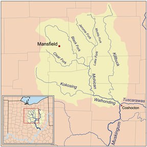
The Clear Fork rises in northeastern Morrow County and flows generally eastwardly through southern Richland and Ashland Counties, past the towns of Lexington, Bellville and Butler, and through Mohican State Park. It joins the Black Fork to form the Mohican River in Ashland County, about 2 miles (3.2 km) southwest of Loudonville.[4]
Upstream of Lexington, a 1949 dam causes the river to form Clear Fork Reservoir, which provides drinking water to the city of Mansfield.[5] In Ashland County, a 1936 U.S. Army Corps of Engineers dam causes the river to form Pleasant Hill Lake.[6]
See also
References
- U.S. Geological Survey Geographic Names Information System: Clear Fork Mohican River
- https://waterdata.usgs.gov/oh/nwis/annual/?format=sites_selection_links&search_site_no=03133500&agency_cd=USGS&referred_module=sw
- Ohio Department of Natural Resources. A Guide to Ohio Streams. Chapter 10: Major Ohio Watersheds (pdf)
- DeLorme (1991). Ohio Atlas & Gazetteer. Yarmouth, Maine: DeLorme. ISBN 0-89933-233-1.
- City of Mansfield: Clear Fork Reservoir Archived 2006-12-07 at the Wayback Machine
- USACE site for Pleasant Hill Lake