Cibuco, Corozal, Puerto Rico
Cibuco is a barrio in the municipality of Corozal, Puerto Rico. Its population in 2010 was 5,387.[1][2][3]
Cibuco | |
|---|---|
Barrio | |
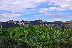 Plantain cultivation in Cibuco | |
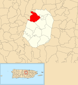 Location of Cibuco within the municipality of Corozal shown in red | |
 Cibuco Location of Puerto Rico | |
| Coordinates: 18°20′26″N 66°20′37″W | |
| Commonwealth | |
| Municipality | |
| Elevation | 312 ft (95 m) |
| Population (2010) | |
| • Total | 5,387 |
| Source: 2010 Census | |
| Time zone | UTC−4 (AST) |
History
The United States took control of Puerto Rico from Spain in the aftermath of the Spanish-American War under the terms of the Treaty of Paris of 1898. In 1899, the United States conducted its first census of Puerto Rico finding that the population of Cibuco barrio was 1,098.[4]
Sectors
Barrios (which are like minor civil divisions)[5] in turn are further subdivided into smaller local populated place areas/units called sectores (sectors in English). The types of sectores may vary, from normally sector to urbanización to reparto to barriada to residencial, among others.[6][7][8]
The following sectors are in Cibuco barrio:[9]
Cibuco 1
Sector Academia, Sector Aníbal Cabranes, Sector Baja del Palo, Sector Boina, Sector Geño Trinidad, Sector La Escuela, Sector Los Crespo, Sector Los Puertos, Sector Los Torres, Sector Los Trinidad, Sector Maguayo, Sector Mingo Negrón, Sector Nela Nevárez, Sector Tomás Colón, Urbanización Estancias de Cibuco, Urbanización Los Próceres, and Urbanización Villas de Cibuco.
Cibuco 2
Extensión Sylvia, Sector Acueducto, Sector Empalme, Sector Guevara, Sector Julio Ortega, Sector Korea, Sector La Mina, Sector Layo Rosado, Sector Los Mangoes, Sector Los Pacheco, Sector Millo Maldonado, Sector Monte de las Brujas, Sector Pepe Pizza, Sector Rolo Barrera, Urbanización Alturas de Cibuco, Urbanización Cibuco, Urbanización Colinas de Corozal, and Urbanización Sylvia.
Cibuco 3
Sector El Vironay, Sector Juan Vázquez, Sector Lin Pérez, Urbanización Valle de Aramaná, and Urbanización Villas de Monte Verde.
References
- Picó, Rafael; Buitrago de Santiago, Zayda; Berrios, Hector H. Nueva geografía de Puerto Rico: física, económica, y social, por Rafael Picó. Con la colaboración de Zayda Buitrago de Santiago y Héctor H. Berrios. San Juan Editorial Universitaria, Universidad de Puerto Rico,1969.
- Gwillim Law (20 May 2015). Administrative Subdivisions of Countries: A Comprehensive World Reference, 1900 through 1998. McFarland. p. 300. ISBN 978-1-4766-0447-3. Retrieved 25 December 2018.
- Puerto Rico:2010:population and housing unit counts.pdf (PDF). U.S. Dept. of Commerce, Economics and Statistics Administration, U.S. Census Bureau. 2010.
- Joseph Prentiss Sanger; Henry Gannett; Walter Francis Willcox (1900). Informe sobre el censo de Puerto Rico, 1899, United States. War Dept. Porto Rico Census Office (in Spanish). Imprenta del gobierno. p. 161.
- "US Census Barrio-Pueblo definition". factfinder.com. US Census. Archived from the original on 13 May 2017. Retrieved 5 January 2019.
- "Agencia: Oficina del Coordinador General para el Financiamiento Socioeconómico y la Autogestión (Proposed 2016 Budget)". Puerto Rico Budgets (in Spanish). Retrieved 28 June 2019.
- Rivera Quintero, Marcia (2014), El vuelo de la esperanza: Proyecto de las Comunidades Especiales Puerto Rico, 1997-2004 (first ed.), San Juan, Puerto Rico Fundación Sila M. Calderón, ISBN 978-0-9820806-1-0
- "Leyes del 2001". Lex Juris Puerto Rico (in Spanish). Retrieved 24 June 2020.
- "PRECINTO ELECTORAL COROZAL 072" (PDF). Comisión Estatal de Elecciones (in Spanish). PR Government. 21 September 2019. Retrieved 24 June 2020.
External links