Chickasha Municipal Airport
Chickasha Municipal Airport (IATA: CHK[2], ICAO: KCHK, FAA LID: CHK) is a city-owned, public-use airport located three nautical miles (6 km) northwest of the central business district of Chickasha, a city in Grady County, Oklahoma, United States.[1] It is included in the National Plan of Integrated Airport Systems for 2011–2015, which categorized it as a general aviation facility.[3]
Chickasha Municipal Airport | |||||||||||||||||||
|---|---|---|---|---|---|---|---|---|---|---|---|---|---|---|---|---|---|---|---|
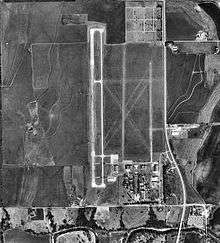 1995 USGS image | |||||||||||||||||||
| Summary | |||||||||||||||||||
| Airport type | Public | ||||||||||||||||||
| Owner | City of Chickasha | ||||||||||||||||||
| Serves | Chickasha, Oklahoma | ||||||||||||||||||
| Location | Grady County, near Chickasha, Oklahoma | ||||||||||||||||||
| Elevation AMSL | 1,152 ft / 351 m | ||||||||||||||||||
| Coordinates | 35°05′50″N 097°58′04″W | ||||||||||||||||||
| Website | Chickasha.org/airport/ | ||||||||||||||||||
| Map | |||||||||||||||||||
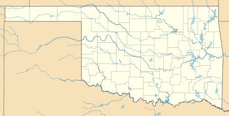 CHK Location of airport in Oklahoma | |||||||||||||||||||
| Runways | |||||||||||||||||||
| |||||||||||||||||||
| Statistics (2010) | |||||||||||||||||||
| |||||||||||||||||||
Facilities and aircraft
Chickasha Municipal Airport covers an area of 720 acres (291 ha) at an elevation of 1,152 feet (351 m) above mean sea level. It has one paved runway designated 17/35 with a concrete surface measuring 5,101 by 100 feet (1,555 x 30 m). It also has two unpaved runways with turf surfaces: 18/36 is 2,840 by 145 feet (866 x 44 m) and 2/20 is 2,525 by 100 feet (770 x 30 m).[1]
For the 12-month period ending November 8, 2010, the airport had 4,000 general aviation aircraft operations, an average of 10 per day. At that time there were 36 aircraft based at this airport: 80% single-engine, 17% multi-engine, and 3% helicopter.[1]
History
Opened in October, 1941 as Wilson-Bonifils Field, the airport conducted contract basic flying training for the United States Army Air Forces. The contractor was the Wilson-Bonfils Flying Schools. Flying training was performed with Fairchild PT-19s as the primary trainer. Also had several PT-17 Stearmans and a few P-40 Warhawks assigned. The wartime airport had up to six grass runways, with the runways being changed at various times.
Appears that there may have been four auxiliaries associated with Chickasha - Aux #1, Aux #2, Aux #3 & Aux #4 but unconfirmed and location unknown.
Deactivated on 1 May 1945 with the drawdown of AAFTC's pilot training program. The airfield was turned over to civil control at the end of the war though the War Assets Administration (WAA).
References
![]()
- Shaw, Frederick J. (2004), Locating Air Force Base Sites History's Legacy, Air Force History and Museums Program, United States Air Force, Washington DC, 2004.
- Manning, Thomas A. (2005), History of Air Education and Training Command, 1942–2002. Office of History and Research, Headquarters, AETC, Randolph AFB, Texas ASIN: B000NYX3PC
- FAA Airport Master Record for CHK (Form 5010 PDF). Federal Aviation Administration. Effective May 31, 2012.
- "Airline and Airport Code Search". International Air Transport Association (IATA). Retrieved November 29, 2012.
- "2011–2015 NPIAS Report, Appendix A" (PDF). National Plan of Integrated Airport Systems. Federal Aviation Administration. October 4, 2010. Archived from the original (PDF, 2.03 MB) on 2012-09-27.
External links
- Chickasha Municipal Airport at City of Chickasha website
- Chickasha Municipal (CHK) at Oklahoma Aeronautics Commission
- Aerial image as of February 1995 from USGS The National Map
- FAA Terminal Procedures for CHK, effective August 13, 2020
- Chickasha Wings Inc , Flight school started in 2003.
- Resources for this airport:
- FAA airport information for CHK
- AirNav airport information for KCHK
- ASN accident history for CHK
- FlightAware airport information and live flight tracker
- NOAA/NWS weather observations: current, past three days
- SkyVector aeronautical chart, Terminal Procedures
| Flying Training |
|  | ||||
|---|---|---|---|---|---|---|
| Technical Training |
| |||||