Chestnut Ridge (Laurel Highlands)
Chestnut Ridge is the westernmost ridge of the Allegheny Mountains in Pennsylvania. It is located primarily within the Laurel Highlands region of southwestern Pennsylvania, extending into northern West Virginia.

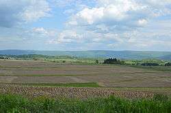
Fields south of Uniontown, with the western side of Chestnut Ridge in the background
Geography
Chestnut Ridge rises in southern Indiana County and continues to the south-southwest for approximately 75 miles. The ridge crosses Westmoreland County and Fayette County into West Virginia then gradually disappears into a series of hills and finally ends roughly 5 miles (8.0 km) southeast of Morgantown, West Virginia.
The ridge passes near the cities of: Blairsville, Derry, Latrobe, Mt. Pleasant, Connellsville, and Uniontown in Pennsylvania; and Morgantown in West Virginia.
The Chestnut Ridge people take their name from this region.
gollark: In the 2022-2023 fiscal year, we intend to get more GPU compute and upgrade the neural nets.
gollark: Worse than the helloboi neural nets.
gollark: For a Markov chain, it writes surprisingly nonawfully.
gollark: osmarkscalculator™ has a bunch of accursedly duplicated code for this reason.
gollark: It can infer types fine, it just won't let you mutably borrow things in multiple things even when it's technically entirely valid.
External links
| Wikimedia Commons has media related to Chestnut Ridge (Laurel Highlands). |
This article is issued from Wikipedia. The text is licensed under Creative Commons - Attribution - Sharealike. Additional terms may apply for the media files.