Chek Keng
Chek Keng (Chinese: 赤徑) is an area and village of Hong Kong. Located within Sai Kung East Country Park,[1] on the northern coast of Sai Kung Peninsula and facing Long Harbour, it is administratively part of Tai Po District.
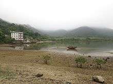
A foggy spring day
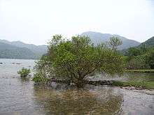
Mangrove at Chek Keng.
.jpg)
Bradbury Hall youth hostel
Features
Transportation
A kai-to service is available between Wong Shek, Wan Tsai (Nam Fung Wan) and Chek Keng.[5]
gollark: I write C by hand with the type checker turned off.
gollark: As someone who never makes any mistakes, I don't need a programming language to hold my hand!
gollark: And the thing (a mobile bee deployment platform) needs that DMP thing to track its orientation.
gollark: The code is all running on an RPi, but the "DMP" features in the MPU6050 are poorly documented and the reverse engineered drivers are in C++.
gollark: Unfortunately, I'm working on a robotics thing for which I have to use C++ due to bad drivers for an accelerometer/gyroscope chip.
References
- Agriculture, Fisheries and Conservation Department: Sai Kung East Country Park Archived 2014-08-23 at the Wayback Machine
- "The abandoned churches of Sai Kung: how Italian missionaries established Hakka congregations in Hong Kong". South China Morning Post. 28 February 2016.
- Historic Building Appraisal: Holy Family Chapel, Chek Keng, Tai Po, New Territories
- Hong Kong Youth Hostels Association: Bradbury Hall Archived September 7, 2014, at the Wayback Machine
- Transport Department: Kaito Ferry Services
External links
| Wikimedia Commons has media related to Chek Keng. |
This article is issued from Wikipedia. The text is licensed under Creative Commons - Attribution - Sharealike. Additional terms may apply for the media files.