Chantry Island (Ontario)
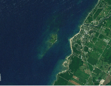
Chantry Island is a small island in Lake Huron, south of the mouth of the Saugeen River and approximately a kilometre off the shores of the town of Southampton, Ontario and south of the mouth of the Saugeen River on Lake Huron. It is approximately 19 hectares (47 acres) in size and is a migratory bird sanctuary.[1] Since the sanctuary territory extends 183 metres into the water surrounding the island, the total official area is listed as 63 hectares (160 acres).[2]


British naval officer and surveyor Henry Wolsey Bayfield named the island in 1822 after the British sculptor Francis Leggatt Chantrey.[3] The island was designated as one of the Canadian Wildlife Service's migratory bird sanctuaries in 1957 because it is an important migratory stop for birds traveling to northern nesting sites. At certain times of year, it is home for many mating birds including, double crested cormorant, seagulls, herring gull, ring billed gull, black-crowned night herons, great blue herons and great egrets.[4]
Fisheries and Oceans Canada owns the island (and some of the surrounding water) and leases it to the Municipality of Saugeen Shores, Ontario. The Ontario region of the Canadian Wildlife Service manages the sanctuary.[3]
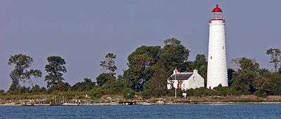
The island is the location of one of the six Imperial Towers, the Chantry Island Lighthouse, which was constructed in 1859; the keeper's dwelling was built at the same time. Fully restored, both are listed on the Canadian Register of Historic Places.[5][6]
Because the island is a bird sanctuary, only a single company, the Marine Heritage Society, has a permit to take visitors for a tour of the lightstation, several times a week from late May to mid-September; the rest of the island is off limits to such visitors.[3]
References
- "Chantry Island Migratory Bird Sanctuary". Chantry Island. Environment and Climate Change Canada. 2 March 2016. Retrieved 20 March 2017.
...the MBS boundary extends 183 m offshore from the normal high-water mark. At that offshore boundary, the water depth is about 20 m.
- "Chantry Island Migratory Bird Sanctuary". Environment and Climate Change Canada. Government of Canada.
- "About Chantry Island". Chantry Island. Marine Heritage Society. 2 March 2016. Retrieved 28 February 2017.
It is the largest Federal Migratory Bird Sanctuary between James Bay and Point Pelee. There are approximately fifty thousand birds (including chicks) on the island during the breeding season.
- "Chantry Island ON154". IBA Canada. IBA Canada.
- "Tower Chantry Island, Ontario, Canada". Canada's Historic Places. Administered by Parks Canada. Retrieved 18 March 2017.
- "Chantry Island, Lightkeeper's Dwelling". Historic Places. Parks Canada. Retrieved 18 March 2017.
External links
- ChantryIsland.com (Marine Heritage Society) - Official website