Chantalvergyrgyn
The Chantalvergyrgyn (Russian: Чантальвэргыргын),[1] also called the Chantalveergyn, is a stream located in Chukotka Autonomous Okrug, in the Far East of Russia. It flows roughly northeastwards and then eastwards from Central Chukotka into the Ekityki from its left side. It is 222 kilometres (138 mi) long, and has a drainage basin of 6,620 square kilometres (2,560 sq mi).[2] Its source is very close to the Arctic Circle.
| Chantalvergyrgyn | |
|---|---|
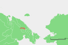 Location of the Chantalvergyrgyn course | |
| Location | |
| Country | Russia |
| Physical characteristics | |
| Mouth | Ekityki |
• coordinates | 67°39′27″N 179°21′53″W |
| Length | 222 km (138 mi) |
| Basin size | 6,620 km2 (2,560 sq mi) |
| Basin features | |
| Progression | Ekityki→ Amguema→ East Siberian Sea |
The Chantalvergyrgyn limits the western side of the Chantal Range of the Chukotka Mountains, just south of the Iskhodnaya.[3] It passes through sparsely populated areas. Winters in its area are long and bitter, so that its surface remains frozen for over eight months every year. Salmon, whitefish, vendace, grayling, rainbow herring, pike, burbot, bull trout, and loach are common in its waters.
References
- Словарь названий гидрографических объектов России и других стран — членов СНГ, Federal Service for Geodesy and Cartography of Russia, 1999, p. 423
- Река Чантальвеергын in the State Water Register of Russia (Russian)
- Wielka Encyklopedia Gór i Alpinizmu, tom 2 Góry Azji, Katowice: Wydawnictwo STAPIS, 2005, ISBN 83-88212-42-7.