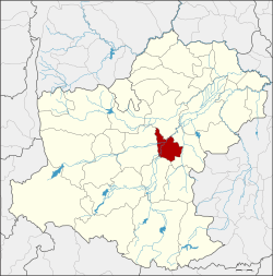
Chaloem Phra Kiat District, Nakhon Ratchasima
Chaloem Phra Kiat (Thai: เฉลิมพระเกียรติ, pronounced [t͡ɕʰā.lɤ̌ːm pʰráʔ kìa̯t]) is a district (amphoe) in the eastern part of Nakhon Ratchasima Province, northeastern Thailand.
Chaloem Phra Kiat เฉลิมพระเกียรติ | |
|---|---|
 District location in Nakhon Ratchasima Province | |
| Coordinates: 15°0′18″N 102°16′18″E | |
| Country | Thailand |
| Province | Nakhon Ratchasima |
| Seat | Tha Chang |
| Area | |
| • Total | 254.1 km2 (98.1 sq mi) |
| Population (2000) | |
| • Total | 33,151 |
| • Density | 130.5/km2 (338/sq mi) |
| Time zone | UTC+7 (ICT) |
| Postal code | 30230, 30000 |
| Geocode | 3032 |
History
Five tambons were separated from Chakkarat District to create the new district on 5 December 1996. It was one of five districts named Chaloem Phra Kiat created on the same date to commemorate the 50th anniversary of the ascension to the throne of King Bhumibol Adulyadej (Rama IX).[1]
Geography
Neighbouring districts are (from the north clockwise): Non Sung, Chakkarat, Chok Chai and Mueang Nakhon Ratchasima.
Administration
The district is divided into five subdistricts (tambons). The township (thesaban tambon) of Tha Chang covers parts of tambons Tha Chang and Chang Thong.
| 1. | Chang Thong | ช้างทอง | |
| 2. | Tha Chang | ท่าช้าง[2] | |
| 3. | Phra Phut | พระพุทธ | |
| 4. | Nong Ngu Lueam | หนองงูเหลือม | |
| 5. | Nong Yang | หนองยาง |
gollark: Just run miners on each?
gollark: ***magic***
gollark: Really, the best way is to just create your own universe and wait for it to evolve to contain the right data.
gollark: (`ed`)
gollark: It's reliable, intuitive and speedy.
See also
References
- พระราชกฤษฎีกาตั้งอำเภอเฉลิมพระเกียรติ จังหวัดนครราชสีมา อำเภอเฉลิมพระเกียรติ จังหวัดนครศรีธรรมราช อำเภอเฉลิมพระเกียรติ จังหวัดน่าน อำเภอเฉลิมพระเกียรติ จังหวัดบุรีรัมย์ และอำเภอเฉลิมพระเกียรติ จังหวัดสระบุรี พ.ศ. ๒๕๓๙ (PDF). Royal Gazette (in Thai). 113 (62 ก): 1–4. November 20, 1996.
- พระราชกฤษฎีกาเปลี่ยนนามอำเภอ กิ่งอำเภอ และตำบลบางแห่ง พุทธศักราช ๒๔๘๒ (PDF). Royal Gazette (in Thai). 56 (0 ก): 354–364. April 17, 1939.
External links
This article is issued from Wikipedia. The text is licensed under Creative Commons - Attribution - Sharealike. Additional terms may apply for the media files.