Chère
The Chère (French: la Chère) is a 65.1 km (40.5 mi) long river in the Loire-Atlantique and Ille-et-Vilaine départements, western France.[1] Its source is at Soudan. It flows generally west. It is a left tributary of the Vilaine into which it flows between Pierric and Sainte-Anne-sur-Vilaine.
| Chère | |
|---|---|
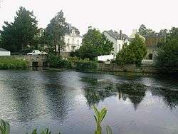
 The Chère at Châteaubriant. | |
| Location | |
| Country | France |
| Physical characteristics | |
| Source | |
| • location | Soudan |
| • coordinates | 47°42′01″N 01°17′25″W |
| • elevation | 80 m (260 ft) |
| Mouth | |
• location | Vilaine |
• coordinates | 47°42′25″N 01°50′13″W |
• elevation | 3 m (9.8 ft) |
| Length | 65.1 km (40.5 mi) |
| Basin size | 390 km2 (150 sq mi) |
| Discharge | |
| • average | 2.4 m3/s (85 cu ft/s) |
| Basin features | |
| Progression | Vilaine→ Atlantic Ocean |
Communes along its course
This list is ordered from source to mouth:
- Loire-Atlantique: Soudan, Châteaubriant, Rougé, Saint-Aubin-des-Châteaux, Sion-les-Mines, Mouais, Derval,
- Ille-et-Vilaine: Grand-Fougeray,
- Loire-Atlantique: Pierric,
- Ille-et-Vilaine: Sainte-Anne-sur-Vilaine
Notes
| Wikimedia Commons has media related to Chère. |
gollark: Giant Cuboid with Windows 1, 2, 3 and 4 are great places to live.
gollark: Have you seen my work?
gollark: I am a GREAT designer.
gollark: PotatOS is the *best* OS.
gollark: I'd be excellent running security for Keansia, I've caused many things to be banned due to their inherent security problems!
This article is issued from Wikipedia. The text is licensed under Creative Commons - Attribution - Sharealike. Additional terms may apply for the media files.