Castelnau-Montratier
Castelnau-Montratier (Languedocien: Castèlnau de Montratièr) is a former commune in the Lot department in south-western France. On 1 January 2017, it was merged into the new commune Castelnau-Montratier-Sainte-Alauzie.[2]
Castelnau-Montratier | |
|---|---|
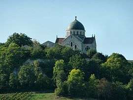 The church of Saint-Martin, in Castelnau-Montratier | |
.svg.png) Coat of arms | |
Location of Castelnau-Montratier 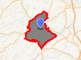
| |
 Castelnau-Montratier  Castelnau-Montratier | |
| Coordinates: 44°16′11″N 1°21′14″E | |
| Country | France |
| Region | Occitanie |
| Department | Lot |
| Arrondissement | Cahors |
| Canton | Marches du Sud-Quercy |
| Commune | Castelnau-Montratier-Sainte-Alauzie |
| Area 1 | 72.54 km2 (28.01 sq mi) |
| Population (2017)[1] | 1,772 |
| • Density | 24/km2 (63/sq mi) |
| Time zone | UTC+01:00 (CET) |
| • Summer (DST) | UTC+02:00 (CEST) |
| Postal code | 46170 |
| Elevation | 108–295 m (354–968 ft) (avg. 248 m or 814 ft) |
| 1 French Land Register data, which excludes lakes, ponds, glaciers > 1 km2 (0.386 sq mi or 247 acres) and river estuaries. | |
Geography
The Barguelonne flows southwestward through the northern part of the commune.
gollark: It was quite hard.
gollark: And some other internal things.
gollark: Well, obviously I'd fake the hardware a bit.
gollark: Probably. I may not have copied it *exactly*.
gollark: Oh, that reminds me, it might catch fire, try and avoid that.
See also
References
- Téléchargement du fichier d'ensemble des populations légales en 2017, INSEE
- Arrêté préfectoral 3 August 2016 (in French)
| Wikimedia Commons has media related to Castelnau-Montratier. |
| Authority control |
|
|---|
This article is issued from Wikipedia. The text is licensed under Creative Commons - Attribution - Sharealike. Additional terms may apply for the media files.