Carrizo Badlands
The Carrizo Badlands are a landform of badlands that lie within Anza-Borrego Desert State Park in eastern San Diego County, and in the Carrizo Impact Area in western Imperial County, in southern California.[1]
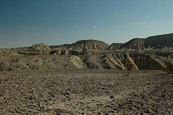
View southwest across the Carrizo Badlands from the Wind Caves, in Anza-Borrego Desert State Park.
Geography
The badlands lie south of the Vallecito Mountains and Fish Creek Mountains, and north of the Tierra Blanca Mountains and Coyote Mountains.
The Carrizo Badlands are bisected by the Carrizo Valley, created by the erosion of the badlands by Carrizo Creek, and ending in the Carrizo Wash, 3 miles east of the site of the old Carrizo Creek Station.[1][2] Vallecito Creek is a major tributary of Carrizo Creek.
- Features
One of the features within the Carrizo Badlands are the Mud Caves in Arroyo Tapiado.
gollark: Generally ext4 is good.
gollark: The symlink thing? I think so. You will need to automount the disk, probably.
gollark: What ”sort” of ”special case”?
gollark: That was someone else.
gollark: `peripheral.wrap(computer).turnOn()`
References
- U.S. Geological Survey Geographic Names Information System: Carrizo Badlands
- USGS topographic maps; Carrizo Mountain, Sweeney Pass, Arroyo Tapiado
This article is issued from Wikipedia. The text is licensed under Creative Commons - Attribution - Sharealike. Additional terms may apply for the media files.