Carraízo
Carraízo is a barrio in the municipality of Trujillo Alto, Puerto Rico. Its population in 2010 was 16,399.[3][4][5]
Carraízo | |
|---|---|
Barrio | |
.jpg) Loíza Lake in Trujillo Alto | |
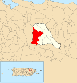 Location of Carraízo within the municipality of Trujillo Alto shown in red | |
 Carraízo Location of Puerto Rico | |
| Coordinates: 18°20′07″N 66°01′30″W[1] | |
| Commonwealth | |
| Municipality | |
| Area | |
| • Total | 5.34 sq mi (13.8 km2) |
| • Land | 5.00 sq mi (12.9 km2) |
| • Water | 0.34 sq mi (0.9 km2) |
| Elevation | 459 ft (140 m) |
| Population (2010) | |
| • Total | 16,399 |
| • Density | 3,279.8/sq mi (1,266.3/km2) |
| Source: 2010 Census | |
| Time zone | UTC−4 (AST) |
History
The United States took control of Puerto Rico from Spain in the aftermath of the Spanish-American War under the terms of the Treaty of Paris of 1898. In 1899, the United States conducted its first census of Puerto Rico finding that the population of Carraízo barrio was 1,159.[6]
Carraízo Dam and Loíza Lake
The Loíza Lake is a reservoir located in Carraizo, formed by the construction of the Carraízo Dam on the Río Grande de Loíza. It serves as the main water supply source of the San Juan metropolitan area.[7][8][9]
Gallery
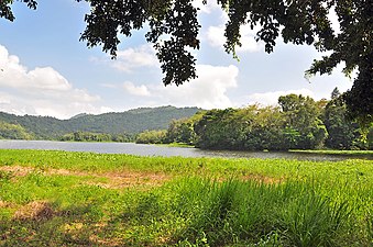 View of Loíza Lake
.jpg) Shack near Loíza Lake
Shack near Loíza Lake
gollark: disguise yourself as a normal user.
gollark: Yes, just mute the entire server for a few hours>
gollark: You just need to be admin until the election.
gollark: Don't ACTUALLY quit.
gollark: NOT STRAWPOLL.
See also
References
- "US Gazetteer 2019". US Census. US Government.
- U.S. Geological Survey Geographic Names Information System: Carraízo barrio
- Picó, Rafael; Buitrago de Santiago, Zayda; Berrios, Hector H. Nueva geografía de Puerto Rico: física, económica, y social, por Rafael Picó. Con la colaboración de Zayda Buitrago de Santiago y Héctor H. Berrios. San Juan Editorial Universitaria, Universidad de Puerto Rico,1969.
- Gwillim Law (20 May 2015). Administrative Subdivisions of Countries: A Comprehensive World Reference, 1900 through 1998. McFarland. p. 300. ISBN 978-1-4766-0447-3. Retrieved 25 December 2018.
- Puerto Rico:2010:population and housing unit counts.pdf (PDF). U.S. Dept. of Commerce, Economics and Statistics Administration, U.S. Census Bureau. 2010.
- Joseph Prentiss Sanger; Henry Gannett; Walter Francis Willcox (1900). Informe sobre el censo de Puerto Rico, 1899, United States. War Dept. Porto Rico Census Office (in Spanish). Imprenta del gobierno. p. 162.
- U.S. Geological Survey
- Gellis, A.C.; Webb, R.M.; Wolfe, W.J.; McIntyre, S.C. (2 February 2012). "USGS Publications Warehouse". Water-Resources Investigations Report. doi:10.3133/wri994010. Retrieved 14 June 2020.
- "Land Use 1950, 1977, 1987 maps" (PDF). USGS. US Dept of the Interior. Retrieved 14 June 2020.
This article is issued from Wikipedia. The text is licensed under Creative Commons - Attribution - Sharealike. Additional terms may apply for the media files.