Carlota Cove
Carlota Cove is the 1.9 km wide cove indenting for 1.14 km the northwest coast of Alfatar Peninsula, Robert Island in the South Shetland Islands, Antarctica next east of Coppermine Peninsula, and entered between Fort William and Misnomer Point. The area was visited by early 19th century sealers operating from neighbouring Clothier Harbour.
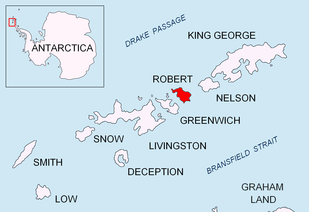
Location of Robert Island in the South Shetland Islands.
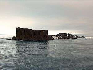
Carlota Cove (on the left) from English Strait, with Fort William in the foreground.

Topographic map of Livingston Island, Greenwich, Robert, Snow and Smith Islands.
The feature was surveyed and named by the 1949 Chilean Antarctic Expedition under Captain Leopoldo Fontaine.
Location
The cove's midpoint is located at 62°22′15.7″S 59°41′47.9″W (British mapping in 1935, 1967 and 1968, Argentine in 1957 and 1980, Chilean in 1961 and 1971, and Bulgarian in 2009).
gollark: ```lualet otherTesting = [];for(let i = 0; i < 10; i++) { otherTesting[i] = function() { console.log(i); }}```does the same thing so I suppose it's just weirdness with closure in loops.
gollark: Er, 9, not 10.
gollark: Hmm, I'd really expect that to print `10`, weird.
gollark: Unrelatedly, it turns out that the large amount of 2-letter TLDs which exist now combined with the fact that 36^3 is a lot means that you can get 6-letter domains, and I mean 6 letter including the TLD and dot.
gollark: It also seems like a terrible protocol, design-wise.
See also
- Alfatar Peninsula
- Robert Island
Map
- L.L. Ivanov. Antarctica: Livingston Island and Greenwich, Robert, Snow and Smith Islands. Scale 1:120000 topographic map. Troyan: Manfred Wörner Foundation, 2009. ISBN 978-954-92032-6-4
This article is issued from Wikipedia. The text is licensed under Creative Commons - Attribution - Sharealike. Additional terms may apply for the media files.