Cariz Point
Cariz Point (Agrelo Point) is the rocky north extremity of Nelson Island in the South Shetland Islands, Antarctica. It forms the east entrance point of Quesada Cove and is located at 62°13′57″S 59°03′00″W, which is 2.5 km northeast of Meana Point, 3.7 km west-northwest of Rip Point, and 1.7 km southwest of Exotic Point on King George Island. British mapping of the area in 1968.
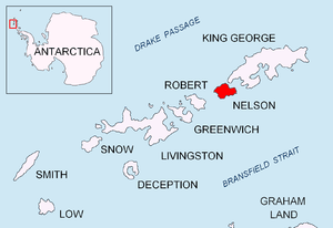
Location of Nelson Island in the South Shetland Islands.
Maps
- Livingston Island to King George Island. Scale 1:200000. Admiralty Nautical Chart 1776. Taunton: UK Hydrographic Office, 1968
- South Shetland Islands. Scale 1:200000 topographic map No. 3373. DOS 610 - W 62 58. Tolworth, UK, 1968
- Antarctic Digital Database (ADD). Scale 1:250000 topographic map of Antarctica. Scientific Committee on Antarctic Research (SCAR). Since 1993, regularly upgraded and updated
gollark: Wait, wouldn't that either just end up hardcoding a big list of sites *or* end up just having to pull from search engines?
gollark: > also can you please pm me the connection finder tool (you write the username and it finds accounts of the same person on other sites)ħħħħħ
gollark: Inconveniently enough, both of them rely heavily on mutable state and are hard to test.
gollark: https://github.com/TomSmeets/FractalArt/blob/master/src/Main.hs vs https://pastebin.com/diwDBnvA.
gollark: I don't know either. I mostly ported it from Haskell and guessed roughly what each bit did.
References
- Cabo Cariz. Composite Antarctic Gazetteer
- Cabo Agrelo. Composite Antarctic Gazetteer
This article is issued from Wikipedia. The text is licensed under Creative Commons - Attribution - Sharealike. Additional terms may apply for the media files.