Cape Patience
Cape Patience (Russian: Полуостров Терпения, Poluostrov Terpeniya) is a peninsula protruding 65 km (40 mi) km of east-central Sakhalin Island into the Sea of Okhotsk. It forms the eastern boundary of the Gulf of Patience. The width of the peninsula varies from less than 1 km (0.62 mi), at the Lodochniy Isthmus, to 30 km (19 mi) at its widest point. It reaches a maximum elevation of 350 m (1,150 ft). The cape is the southernmost extension (on land) of the East Sakhalin Mountains, a north-south range that runs along the eastern side of Sakhalin Island.[1]
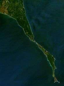
View of Cape Patience from space.
.svg.png)
This map shows Poronaysky District; Cape Patience is the skinny peninsula in the southeastern part.
There is a small lighthouse at the end of the cape, which was built in 1953.[2]
Climate
| Climate data for Cape Patience | |||||||||||||
|---|---|---|---|---|---|---|---|---|---|---|---|---|---|
| Month | Jan | Feb | Mar | Apr | May | Jun | Jul | Aug | Sep | Oct | Nov | Dec | Year |
| Record high °C (°F) | 2.2 (36.0) |
2.5 (36.5) |
5.1 (41.2) |
13.9 (57.0) |
21.1 (70.0) |
26.1 (79.0) |
25.0 (77.0) |
28.9 (84.0) |
26.1 (79.0) |
18.9 (66.0) |
12.2 (54.0) |
6.1 (43.0) |
28.9 (84.0) |
| Average high °C (°F) | −9.1 (15.6) |
−8.7 (16.3) |
−4 (25) |
0.9 (33.6) |
4.0 (39.2) |
8.1 (46.6) |
12.1 (53.8) |
14.8 (58.6) |
13.3 (55.9) |
8.6 (47.5) |
1.6 (34.9) |
−4.7 (23.5) |
3.1 (37.5) |
| Daily mean °C (°F) | −11.5 (11.3) |
−11.7 (10.9) |
−6.7 (19.9) |
−1.2 (29.8) |
2.0 (35.6) |
5.8 (42.4) |
9.9 (49.8) |
12.3 (54.1) |
11.2 (52.2) |
6.6 (43.9) |
−0.5 (31.1) |
−6.9 (19.6) |
0.8 (33.4) |
| Average low °C (°F) | −14 (7) |
−14.6 (5.7) |
−9.5 (14.9) |
−3.2 (26.2) |
−0.1 (31.8) |
3.5 (38.3) |
7.7 (45.9) |
9.8 (49.6) |
9.0 (48.2) |
4.6 (40.3) |
−2.7 (27.1) |
−9.1 (15.6) |
−1.6 (29.2) |
| Record low °C (°F) | −27.9 (−18.2) |
−29.1 (−20.4) |
−23.4 (−10.1) |
−18.5 (−1.3) |
−7 (19) |
−4.7 (23.5) |
-0 (32) |
3.6 (38.5) |
1.1 (34.0) |
−5.4 (22.3) |
−14.9 (5.2) |
−25.8 (−14.4) |
−29.1 (−20.4) |
| Average precipitation mm (inches) | 32.8 (1.29) |
25.7 (1.01) |
29.5 (1.16) |
28.4 (1.12) |
38.9 (1.53) |
32.2 (1.27) |
54.8 (2.16) |
66.6 (2.62) |
76.1 (3.00) |
61.1 (2.41) |
49.6 (1.95) |
38.9 (1.53) |
534.6 (21.05) |
| Average precipitation days (≥ 1.0 mm) | 6.6 | 5.3 | 6.3 | 5.6 | 6.5 | 5.4 | 6.1 | 7.0 | 7.5 | 9.0 | 9.4 | 8.3 | 83 |
| Source 1: Météo climat stats[3] Météo Climat [4] | |||||||||||||
| Source 2: Roshydromet (records)[5] | |||||||||||||
gollark: Use hair spaces and proportional fonts.
gollark: These are both bad. Constant fold to 10.
gollark: You should use my advanced chat program to coordinate.
gollark: You have GROUP programming projects?
gollark: Why not?
References
- ov, E. P., A. V. Mozherovsky, M. T. Gorovaya, I. B. Tsoy, and N. G. Vashchenkova. Composition of the Rocks of the Kotikovo Group and the Main Stages in the Late Cretaceous-Paleogene Evolution of the Terpeniya Peninsula, Sakhalin Island. Russian Journal of Pacific Geology 4.3 (2010): 260-73.
- Lighthouse Explorer Database ... Terpeniya Light. Foghorn Publishing, Lighthouse Explorer Database. Retrieved 22 Sept. 2012.
- "Moyennes 1981-2010 Russie (Asie)" (in French). Retrieved 8 November 2019.
- "Météo Climat stats for Mys Terpenij". Météo Climat. Retrieved 8 November 2019.
- "Climate of Cape Patience" (in Russian). Weather and Climate (Погода и климат). Retrieved 8 November 2019.
This article is issued from Wikipedia. The text is licensed under Creative Commons - Attribution - Sharealike. Additional terms may apply for the media files.