Cape Discord
Cape Discord (Danish: Kap Discord), also known as Kangeq, is a headland in the North Atlantic Ocean, southeast Greenland, Kujalleq municipality.[1]
| Cape Discord | |
|---|---|
| Kap Discord, Kangeq | |
 | |
| Location | King Frederick VI Coast |
| Coordinates | 60°53′N 42°38′W |
| Offshore water bodies | North Atlantic Ocean |
| Elevation | 430 m (1,410 ft) |
| Area | Arctic |
History
Cape Discord was named in old maps before Lieutenant Wilhelm August Graah passed it in 1829 during his East Coast expedition. Graah took a latitude observation at the headland.[2]
Geography
Cape Discord is located east of Danell Fjord, at the eastern end of Iluileq Island, 11 km (6.8 mi) northeast of the mouth of Paatusoq Fjord.[3] The entrance of Kangerluk Fjord is 7 km (4.3 mi) NW and that of Kuutseq Fjord 20 km (12 mi) SSW of the cape.[4]
 Map of Greenland section showing Iluileq. |
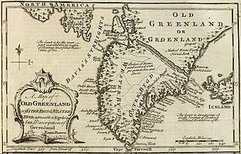 1747 map of Greenland showing Cape Discord. |
gollark: Bad Idea #82995: Mageia Xenowyrm BSA to teleport all eggs from the AP to random scrolls.
gollark: Bad idea #929284818: GoN BSA to earthquake the AP.
gollark: I hope we'll reach ER soon.
gollark: Hi and also are there hatchlings for the new releases visible now?
gollark: Now that I have space for another gusty they're mostly gone. What joy.
References
- Den grønlandske Lods - Sejladsanvisninger Østgrønland, p. 49
- W. A. Graah, Narrative of an Expedition to the East Coast of Greenland, London, 1837 p. 70
- Prostar Sailing Directions 2005 Greenland and Iceland Enroute, p. 100
- "Kap Discord". Mapcarta. Retrieved 2 June 2019.
External links
This article is issued from Wikipedia. The text is licensed under Creative Commons - Attribution - Sharealike. Additional terms may apply for the media files.