Cape Alexander
Cape Alexander (66°44′S 62°37′W) is a cape which forms the south end of Churchill Peninsula and the east side of the entrance to Cabinet Inlet, on the east coast of Graham Land. It was charted by the Falkland Islands Dependencies Survey (FIDS) and photographed from the air by the Ronne Antarctic Research Expedition (RARE) in December 1947.
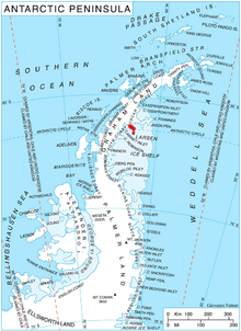
Location of Churchill Peninsula in Graham Land, Antarctic Peninsula.
Cape Alexander was named by the FIDS for Rt. Hon. Albert V. Alexander, M.P., First Lord of the Admiralty.
Further reading
• R. K. Headland, Chronological List of Antarctic Expeditions and Related Historical Events, P 353
• Pedro Skvarca, Changes and surface features of the Larsen Ice Shelf, Antarctica, derived from Landsat and Kosmos mosaics, Annals of Glaciology, Volume 20 1994, PP 6-12
• NATIONAL GEOSPATIAL-INTELLIGENCE AGENCY, SAILING DIRECTIONS & ENROUTE, ANTARCTICA, P 106
Reference
![]()
![]()
gollark: That's why you should run potatOS instead.
gollark: "If loops" don't exist.
gollark: You want to open the microcontroller's wireless card on whatever channel you want to use, then have it listen for modem_message events and handle the associated data. On the computer side, use the `broadcast` function with that channel and whatever data.
gollark: You need a wireless card in each.
gollark: https://ocdoc.cil.li/component:modem
This article is issued from Wikipedia. The text is licensed under Creative Commons - Attribution - Sharealike. Additional terms may apply for the media files.