Cameron Suspension Bridge
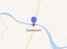
The Cameron Suspension Bridge crosses the Little Colorado River at Cameron, Arizona, United States.
Cameron Suspension Bridge | |
|---|---|
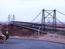 The historic Cameron Suspension Bridge alongside US‑89, July 2006 | |
| Coordinates | 35°52′37″N 111°24′43″W |
| Carries | Natural gas pipeline |
| Crosses | Little Colorado River |
| Locale | Cameron, Arizona United States |
| Characteristics | |
| Design | Suspension |
| Material | Steel |
| Total length | 680 feet (210 m) |
| Height | 14 feet (4.3 m) |
| Longest span | 660 feet (200 m) |
| History | |
| Designer | W. H. Code |
| Opened | 1911 |
| Closed | 1959 |
Cameron Suspension Bridge | |
  | |
| Nearest city | Cameron, Arizona United States |
| Coordinates | 35°52′37.62″N 111°24′42.58″W |
| Area | 0.2 acres (0.081 ha) |
| Built | 1911 |
| Built by | Office of Indian Affairs; Midland Steel Co. |
| Architect | W. H. Code |
| Architectural style | Suspension-truss hybrid, Other |
| MPS | Vehicular Bridges in Arizona MPS |
| NRHP reference No. | 86001206[1] |
| Added to NRHP | June 5, 1986 |
| |
Description
The bridge formerly carried U.S. Route 89, but was replaced by a newer deck truss bridge in 1959. Built in 1911, it has an overall length of 680 feet (210 m) and a main span of 660 feet (200 m). The bridge was built by the Midland Bridge Company of Kansas City for the Office of Indian Affairs and the Indian Irrigation Service. W. H. Code of the Midland Bridge Company was the designer. The suspension design was chosen to address the steep-walled canyon at the crossing, which required a single span with no temporary falsework.[2] When built, the Cameron bridge was the longest suspension span west of the Mississippi River.[3]
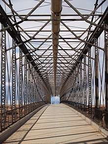
The bridge towers rest on the rim of the canyon, with concrete deadmen anchoring the suspension cables some way back from the towers. The deck is stiffened by a Pratt through-truss, with a 14-foot (4.3 m) wide roadway. The bridge was built to improve access to the Navajo Nation and the Hopi Indian Reservation. Named for U.S. Senator Ralph H. Cameron, it was an important link for the construction of the Navajo Bridge on US 89 across the Colorado River in 1929. The town of Cameron grew up around the crossing, which in addition to opening up the Native American lands to the north, also provided a northern gateway to the South Rim of the Grand Canyon when the Navajo Bridge opened.[2]
The bridge was damaged by an overload of sheep in 1937, when it almost collapsed.[2] The damage was repaired and the bridge served highway traffic until 1959. It was sold to the Four Corners Pipeline Company when the new bridge opened, and carries a natural gas pipeline. It is the oldest suspension bridge in Arizona,[2] and one of only two of that type in the state.[4]
The Cameron Suspension bridge was added to the National Register of Historic Places on June 5, 1986.[1]
See also
- List of bridges on the National Register of Historic Places in Arizona
- National Register of Historic Places listings in Coconino County, Arizona
- Dewey Bridge (Utah), a bridge in Utah built using scaled blueprints of the Cameron Bridge
References
- "National Register Information System". National Register of Historic Places. National Park Service. July 9, 2010.
- Fraser, Clayton B. (October 31, 2004). "Cameron Suspension Bridge" (PDF). Historic Bridge Inventory. Arizona Department of Transportation. pp. 308–311. Archived from the original (PDF) on October 13, 2012. Retrieved July 19, 2012.
- Madrid, Christine L. (1993). "Dewey Bridge, Spanning Colorado River at State Highway 128, Cisco, Grand County, UT" (PDF). Historic American Engineering Record. Library of Congress. Archived from the original (PDF) on October 23, 2012. Retrieved January 25, 2014.
- Fraser, Clayton B. (October 28, 1987). "National Register of Historic Places Multiple Property Documentation Form: Vehicular Bridges of Arizona". National Park Service. p. F.14/3. Retrieved July 19, 2012.
External links
- Historic American Engineering Record (HAER) No. AZ-34, "Cameron Suspension Bridge, Spanning Little Colorado River on Alternate U.S. Route 89, Cameron, Coconino County, AZ"
- Cameron Suspension Bridge at Bridgemeister
| Topics | |
|---|---|
| Lists by state |
|
| Lists by insular areas | |
| Lists by associated state | |
| Other areas | |
| Related | |
| |