Calzada, Maunabo, Puerto Rico
Calzada is a barrio in the municipality of Maunabo, Puerto Rico.[3] Its population in 2010 was 1,082.[4][5][6]
Calzada | |
|---|---|
Barrio | |
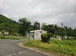 Catholic chapel in Calzada on PR-7761 | |
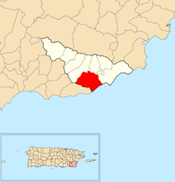 Location of Calzada within the municipality of Maunabo shown in red | |
 Calzada Location of Puerto Rico | |
| Coordinates: 17°59′23″N 65°55′11″W[1] | |
| Commonwealth | |
| Municipality | |
| Area | |
| • Total | 3.78 sq mi (9.8 km2) |
| • Land | 3.24 sq mi (8.4 km2) |
| • Water | 0.54 sq mi (1.4 km2) |
| Elevation | 112 ft (34 m) |
| Population (2010) | |
| • Total | 1,082 |
| • Density | 344.6/sq mi (133.1/km2) |
| Source: 2010 Census | |
| Time zone | UTC−4 (AST) |
History
The United States took control of Puerto Rico from Spain in the aftermath of the Spanish-American War under the terms of the Treaty of Paris of 1898. In 1899, the United States conducted its first census of Puerto Rico finding that the combined population of Calzada and Lizas barrios was 1,233.[7]
Gallery
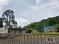 School in Calzada
gollark: This statement is false.
gollark: I think it's an alias for pay.
gollark: /withdraw is for the kristpay thing.
gollark: No, \withdraw is specific to the hydronitrogen sell shop.
gollark: Yes, indeed, because profit margins. I mean, it does have a lower barrier to entry than running your own, and is more convenient, but... well.
See also
References
- "US Gazetteer 2019". US Census. US Government.
- U.S. Geological Survey Geographic Names Information System: Calzada barrio
- "Nuevos Limites Maunabo" (PDF). gis.jp.pr.gov. Puerto Rico Government. Retrieved 11 August 2020.
- Picó, Rafael; Buitrago de Santiago, Zayda; Berrios, Hector H. Nueva geografía de Puerto Rico: física, económica, y social, por Rafael Picó. Con la colaboración de Zayda Buitrago de Santiago y Héctor H. Berrios (in Spanish). San Juan Editorial Universitaria, Universidad de Puerto Rico,1969.
- Gwillim Law (20 May 2015). Administrative Subdivisions of Countries: A Comprehensive World Reference, 1900 through 1998. McFarland. p. 300. ISBN 978-1-4766-0447-3. Retrieved 25 December 2018.
- Puerto Rico:2010:population and housing unit counts.pdf (PDF). U.S. Dept. of Commerce, Economics and Statistics Administration, U.S. Census Bureau. 2010.
- Joseph Prentiss Sanger; Henry Gannett; Walter Francis Willcox (1900). Informe sobre el censo de Puerto Rico, 1899, United States. War Dept. Porto Rico Census Office (in Spanish). Imprenta del gobierno. p. 163.
External links
- Jan. 15, 2019 video of Calzada
- Non-profit reparing homes in 2019 that were destroyed by Hurricane Maria in Calzada in 2017
This article is issued from Wikipedia. The text is licensed under Creative Commons - Attribution - Sharealike. Additional terms may apply for the media files.