California State Route 99
State Route 99 (SR 99), commonly known as Highway 99 or, simply, as 99 (without any further designation), is a north–south state highway in the U.S. state of California, stretching almost the entire length of the Central Valley. From its southern end at Interstate 5 (I-5) near Wheeler Ridge to its northern end at SR 36 near Red Bluff, SR 99 goes through the densely populated eastern parts of the valley. Cities served include Bakersfield, Delano, Tulare, Visalia, Kingsburg, Selma, Fresno, Madera, Merced, Turlock, Modesto, Manteca, Stockton, Sacramento, Yuba City, and Chico.
| ||||
|---|---|---|---|---|
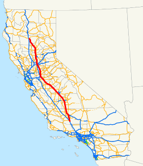 SR 99 highlighted in red | ||||
| Route information | ||||
| Defined by Streets and Highways Code § 399 | ||||
| Maintained by Caltrans | ||||
| Length | 424.85 mi[1] (683.73 km) | |||
| Existed | 1928 as US 99, 1964 as SR 99–present | |||
| Section 1 | ||||
| South end | ||||
| Major junctions | ||||
| North end | ||||
| Section 2 | ||||
| South end | ||||
| Major junctions | ||||
| North end | ||||
| Location | ||||
| Counties | Kern, Tulare, Fresno, Madera, Merced, Stanislaus, San Joaquin, Sacramento, Sutter, Butte, Tehama | |||
| Highway system | ||||
| ||||

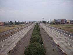
The highway is a remnant of the former Mexico to Canada U.S. Route 99 (US 99), which was decommissioned in 1972 after being functionally replaced by I-5 for long-distance traffic, south of Sacramento. Almost the entirety of the roadway from Wheeler Ridge to Sacramento has been upgraded as of January 2016 to a freeway at least four lanes wide, and the California Department of Transportation (Caltrans) plans to further upgrade the segment to a minimum width of six lanes and also bring it into compliance with Interstate Highway standards, as a parallel route to I-5 for Los Angeles–Sacramento traffic, with plans for it to eventually become either I-7 or I-9. North of Sacramento, the road ranges from a rural two-lane road to a four-lane freeway, much of it the designation of old US 99E.
Route description
SR 99 is part of the California Freeway and Expressway System,[2] and except for a small portion north of SR 20 is part of the National Highway System,[3] a network of highways that are considered essential to the country's economy, defense, and mobility by the Federal Highway Administration.[4]
Wheeler Ridge to Sacramento
From its southern terminus at I-5 in Wheeler Ridge (Wheeler Ridge Interchange) to Sacramento, SR 99 passes through the major cities of the San Joaquin Valley, including Bakersfield, Delano, Tulare, Visalia, Fresno, Madera, Merced, Modesto, and Stockton. The entirety of this segment is now built to freeway standards with complete access control, although some older portions are not yet in compliance with Interstate Highway standards. The portion of the highway between Fresno and Madera has been designated the 100th Infantry Battalion Memorial Highway, honoring the U.S. Army unit that was composed almost entirely with American soldiers of Japanese ancestry when it fought during World War II.[5]
The freeway sections connect and serve the agriculture and industry of the California Central Valley, connecting agricultural production with processing and packing businesses. Most of the freeway also parallels the Union Pacific's Fresno Subdivision.
The portion between Salida and Manteca is designated the 442nd Regimental Combat Team Memorial Highway, honoring the US Army infantry regiment that, like the 100th Infantry Battalion, was also composed almost entirely of American soldiers of Japanese ancestry during World War II.[5]
In Sacramento, SR 99 first joins with I-80 Business as part of the Capital City Freeway, then runs concurrently with I-5. These SR 99 concurrences are not officially designated by Caltrans, but mapmakers often show it as such. SR 99 signage had existed along that route for motorists' convenience along with I-80, but was removed in 2000 on I-5 , 2016 on I-80, and replaced by "TO SR 99" signs instead.
North Sacramento to Red Bluff
SR 99 then splits from I-5 in northern Sacramento, and then heads along the eastern side of the Sacramento Valley through Yuba City, and Chico to its northern terminus at SR 36 near Red Bluff. SR 99 remains a four-lane freeway as the route leaves Sacramento County, but shortly reverts to a four-lane divided expressway as the highway crosses into Sutter County. As SR 99 reaches the junction of SR 70, the route turns northwest by north and becomes an undivided expressway with the exceptions of crossing the Feather River near Nicolaus and the interchange with SR 113, where the route then turns straight north to Yuba City.
As SR 99 crosses SR 20 at a signaled intersection, the highway becomes a four-lane freeway for 3 miles (4.8 km) before reverting to a two-lane road, passing the smaller towns of Live Oak, Fagan, and Gridley. SR 99 briefly is a local four-lane road through Gridley before continuing as a two-lane highway. SR 99 passes by the western side of the Thermalito Afterbay. SR 162 joins SR 99 for 2 miles (3.2 km) before splitting off east towards the northern end of the Thermalito Afterbay. SR 99 then transitions from a two-lane road to a four-lane divided expressway just before the interchange at SR 149 turning northwest and eventually a freeway entering the Chico city limits. As SR 99 leaves Chico, the highway reverts to a 2-lane road before crossing into Tehama County and passing through rural areas and the town of Los Molinos. The route then curves to the west and terminates at the junction with SR 36, approximately 1.5 miles (2.4 km) from I-5 in Red Bluff. This part of the highway is not planned to be I-7/I-9.
History
From initial construction to U.S. Route 99
The first state highway bond issue, approved by the state's voters in 1910,[6] included a north–south highway through the central part of the state consisting of Route 3 through the Sacramento Valley from the Oregon state line south to Sacramento, replacing the Siskiyou Trail, and Route 4 through the San Joaquin Valley from Sacramento to Los Angeles. In addition, a second route followed the west side of the Sacramento Valley, using Route 7 from Red Bluff south to Davis and the short Route 8 east along the proposed Yolo Causeway to Sacramento. North of Bakersfield these closely paralleled some of the main lines of the Southern Pacific Railroad, including the Fresno Line, East and West Valley lines, Shasta Line and Siskiyou Line.
By 1920 paving of both routes from Red Bluff to Los Angeles was completed or in progress, including the only mountain crossing south of Red Bluff, the Ridge Route just north of Los Angeles. To the north of Red Bluff, the road was being graded but not paved over the Siskiyou Mountains into Oregon.[7] Paving was finally completed in mid-1933, when a new alignment (now SR 263) opened through the Shasta River Canyon.[8]
The route from Davis to Oregon via Routes 7 and 3 came to be known as part of the Pacific Highway,[9][10] an auto trail organized in 1910 to connect Canada and Mexico.[11] The split in the Sacramento Valley was known as the East and West Side highways (the latter also carrying the Pacific Highway).[12] South of Sacramento Route 4 was the Valley Route, but the San Joaquin Valley Tourist and Travel Association held a contest to rename it, selecting Golden State Highway as the winning entry in July 1927.[13][14] To this day, "Golden State Highway" is SR 99's default name in areas not given other names by the Legislature, and the name continues from its end at Wheeler Ridge on I-5 as the Golden State Freeway from there to downtown Los Angeles.
This north–south central highway became part of US 99 in 1926, as part of the new United States Numbered Highway System developed by the American Association of State Highway Officials (AASHO),[15] though signs were not posted in California until 1928.[16][17] US 99 also continued southeast from Los Angeles along a paved state highway, Route 9 and 26, to US 80 in El Centro.[18] The paved county road south from El Centro to the Mexican border became a state highway in mid-1931,[19] and part of US 99 in mid-1932.[20]
.svg.png)
.svg.png)
In mid-1929, AASHO approved a split designation between Sacramento and Red Bluff, with US 99W replacing the original western route via Davis, and US 99E following the East Side Highway (Route 3) via Roseville.[21] A short-lived split also existed between Manteca and Stockton in the early 1930s, with US 99E becoming the main route and US 99W becoming an extended SR 120 where not concurrent with US 50.
A third highway heading north from Sacramento was constructed by the Natomas Company in the 1910s for 13 miles (21 km) along the Sacramento River levee to provide access to land reclaimed and sold by the company. Sacramento and Sutter counties continued the road alongside the Sacramento River and Feather River to Nicolaus, where an existing county road crossed the river on a drawbridge and ran north to the East Side Highway at Yuba City.[22] This continuous roadway between Sacramento and Yuba City was dedicated in October 1924 as the Garden Highway.[23]
Parts of the present SR 99 alignment between Sacramento and Yuba City were added to the state highway system in 1933, when the legislature added Route 87 (Sign Route 24,[24] later US 40 Alternate) from Woodland north past Yuba City to northwest of Oroville,[25] and in 1949, with the creation of Route 232 (later Sign Route 24) between Sacramento and Marysville.[26] The final piece became Route 245 (no signed number) in 1959, connecting Route 232 near Catlett with Route 87 near Tudor,[27] and following the old Garden Highway across the Feather River to a point east of Tudor. Despite this combined route connecting the same cities as the Garden Highway, the only other piece of the old county road taken for the state highway was a short segment just north of Sacramento, carrying Route 232 between Jibboom Street and El Centro Road.[28]
As a state route
When the Interstate Highway System was being planned in the 1950s, there were two proposals on which way to route a freeway through the San Joaquin Valley. One was to upgrade US 99 to Interstate standards. The other alternative to build the proposed Westside Freeway, which would bypass all the Central Valley communities and thus provide a faster and more direct north–south route through the state. The latter route, which eventually became I-5, was ultimately chosen.
The implementation of the Interstate Highway System and the mid-1964 state highway renumbering ultimately sealed the fate of the U.S. Highway designation on US 99. The Interstates eventually replaced portions of US 99, causing it to be truncated at both of its ends. Since the remnant did not cross state lines, it was not allowed to keep its U.S. Highway status.
US 99 was truncated to Los Angeles, with the old route south to Mexico becoming mainly I-10 and SR 86. At the same time Route 99 was defined legislatively to run from I-5 near Wheeler Ridge to Red Bluff, but it was only marked as SR 99 between Sacramento and Yuba City, since the remainder was still US 99 or US 99E.[16] The southern end of US 99 was moved further north to Sacramento in late 1966 and SR 99 was extended to Wheeler Ridge; the rest of former US 99 to Los Angeles was either I-5 or the locally maintained San Fernando Road.[29][30] Several years later US 99 and its branches were removed altogether from California, making SR 99 signage match the legislative definition; all of US 99W, and US 99 north of Red Bluff, remained as other routes (I-80, SR 113, and I-5), while US 99E between Roseville and Marysville became SR 65. By 1968, all US 99 signs were removed or replaced with SR 99 signs following the completion of I-5.
During the latter 20th century, Caltrans gradually widened Route 99 into a four-lane expressway for the entire segment from Wheeler Ridge to Sacramento. As traffic levels on the highway continued to increase, the at-grade intersections on the expressway segments became extremely dangerous. Drivers on cross-streets who needed to cross the expressway often had to wait for several minutes to find suitable gaps in which to dart across heavy through traffic on Route 99 moving perpendicular to them at near-freeway speeds. Therefore, those intersections were gradually upgraded or replaced with freeway interchanges, and frontage roads were often added to provide access to adjoining lots. By 2012, there was only one remaining expressway segment with at-grade interchanges on Route 99 between Sacramento and Wheeler Ridge, in Merced County between the cities of Chowchilla and Atwater. On January 15, 2016, Caltrans officially opened the Plainsburg Road interchange, which completed the conversion of Route 99 south of Sacramento close to a freeway with near-interstate standards.
Future
.svg.png)
.svg.png)
Caltrans' long-range plans recommend that SR 99 be upgraded to Interstate Highway standards between its southern end and Sacramento, which would require upgrading some substandard sections. Caltrans indicates the route would be designated as either I-7 or I-9, in accordance with the Interstate Highway System's numbering standards (being just east of and parallel to I-5).[31]
Junction list
Except where prefixed with a letter, postmiles were measured on the road as it was in 1964, based on the alignment that existed at the time, and do not necessarily reflect current mileage. R reflects a realignment in the route since then, M indicates a second realignment, L refers an overlap due to a correction or change, and T indicates postmiles classified as temporary (for a full list of prefixes, see the list of postmile definitions).[32] Segments that remain unconstructed or have been relinquished to local control may be omitted. The numbers reset at county lines; the start and end postmiles in each county are given in the county column.
| County | Location | Postmile [32][1][33] | Exit [34][35] | Destinations | Notes | ||
|---|---|---|---|---|---|---|---|
| Kern KER L0.75–57.58 | Wheeler Ridge | L0.75 | — | Southern terminus of SR 99; no access to I-5 north; former US 99 south; I-5 exit 221 northbound | |||
| Mettler | 2.73 | 3 | |||||
| 4.02 | 4 | Mettler | Southbound exit and entrance | ||||
| | 5.34 | 5 | David Road, Copus Road | ||||
| | 7.29 | 7 | Sandrini Road | ||||
| | 9.30 | 9 | Herring Road | ||||
| | 10.93 | 11 | Union Avenue (SR 99 Bus. north) – Greenfield | Northbound exit and southbound entrance; former US 99 north | |||
| | 13.41 | 13 | |||||
| | 15.43 | 15 | Houghton Road | ||||
| Bakersfield | 17.50 | 18 | Former US 399 | ||||
| 18.52 | 19 | Hosking Avenue | |||||
| 19.54 | 20 | Panama Lane | |||||
| 21.08 | 21 | White Lane | |||||
| 22.60 | 23 | Ming Avenue | |||||
| 23.51– 23.62 | 24 | Southern end of SR 58 overlap | |||||
| 24.60 | 25 | California Avenue – Civic Center | |||||
| 25.65 | 26A | Northern end of SR 58 overlap; signed as exit 26 southbound; northbound entrance is via Buck Owens Boulevard | |||||
| 25.90 | 26B | Buck Owens Boulevard | Northbound exit and entrance | ||||
| 26.78 | 27 | Airport Drive – Oildale | Northbound exit and southbound entrance; serves Meadows Field Airport | ||||
| 27.05 | 27 | Southbound exit and northbound entrance; former US 99 south / US 466 east | |||||
| 27.87 | 28 | Olive Drive | |||||
| R28.56 | 29 | Norris Road – Oildale | Southbound exit and northbound entrance | ||||
| R29.88 | 30 | Northbound exit and southbound entrance | |||||
| R30.53 | 31 | 7th Standard Road, Merle Haggard Drive | |||||
| Shafter | 36.52 | 37 | Lerdo Highway – Shafter | ||||
| | R39.12 | 39 | Merced Avenue | ||||
| | R41.16 | 41 | Kimberlina Road | ||||
| Famoso | 44.31 | 44 | Former US 466 west | ||||
| | R47.37 | 47 | Whisler Road | ||||
| McFarland | 49.30 | 49 | Sherwood Avenue – McFarland | No northbound entrance | |||
| 49.95– 50.41 | 50 | Perkins Avenue, Elmo Highway – McFarland | |||||
| Delano | 52.45 | 52 | Pond Road | ||||
| 54.48 | 54 | Woollomes Avenue (SR 99 Bus. north) | |||||
| 55.52 | 55 | First Avenue | Northbound exit and southbound entrance | ||||
| 55.52 | 56A | Signed as exit 56 northbound | |||||
| 56.10 | 56B | Central Delano (11th Avenue) | Northbound exit is via exit 56 | ||||
| 56.54 | 57 | Cecil Avenue | Southbound entrance is via exit 56B | ||||
| Kern–Tulare county line | 57.58 | 58 | County Line Road (SR 99 Bus. south / CR J44) | ||||
| Tulare TUL 0.00-R53.94 | | 2.02 | 60 | Avenue 16 | Southbound exit and entrance | ||
| | 3.06 | 61 | Avenue 24 | No southbound entrance | |||
| Earlimart | 6.15 | 64 | Avenue 48 – Earlimart | ||||
| 7.17 | 65A | Avenue 56 (CR J22) – Ducor, Alpaugh | Signed as exit 65 northbound; former Legislative Route 135 | ||||
| 7.24 | 65B | Alpaugh (Front Street) | Southbound exit only; former US 99 south | ||||
| | 9.71 | 67 | Avenue 72, Avenue 76 | Signed as Avenue 72 southbound | |||
| | 10.20 | 68 | Avenue 80, Avenue 76 | Southbound exit and northbound entrance | |||
| Pixley | 12.30 | 70A | Avenue 96 (CR J24) – Pixley, Terra Bella | ||||
| 12.80 | 70B | Court Street | No southbound entrance; northbound entrance is via exit 71 | ||||
| 12.90 | 70C | Pixley (Main Street) | Southbound exit only | ||||
| 13.33 | 71 | Road 124 | Northbound exit and entrance | ||||
| | 15.37 | 73 | Avenue 120 | ||||
| Tipton | 18.43 | 76 | |||||
| 19.46 | 77 | Avenue 152 (CR J26) – Tipton | |||||
| | 22.30 | Raine Rest Area | |||||
| Tulare | 23.49 | 81 | Avenue 184 | ||||
| 25.43 | 83 | Avenue 200 (SR 99 Bus. north) | |||||
| 26.05 | K Street (SR 99 Bus. north) | Closed; former northbound left exit | |||||
| 27.60 | 85 | Paige Avenue | |||||
| 28.61 | 86 | Bardsley Avenue | |||||
| 29.57 | 87 | ||||||
| 30.58 | 88 | Hillman Street, Prosperity Avenue, Blackstone Street | |||||
| 31.85 | 89 | M Street, Cartmill Avenue | |||||
| | 90 | Oaks Street | Closed; former northbound exit and entrance | ||||
| | 33.22 | 91 | J Street (SR 99 Bus. south) | No northbound exit; former US 99 south | |||
| | 33.94 | 92 | Avenue 260, Avenue 264 | ||||
| Visalia | 36.41 | 94 | Avenue 280, Caldwell Avenue (CR J30) | ||||
| R38.75 | 97 | Signed as exits 96 (east) and 97 (west) northbound; SR 198 exit 101 | |||||
| Goshen | | 98A | Avenue 304 – Goshen | Closed; former northbound exit and entrance | |||
| 39.93 | 98A | Avenue 304 | Closed; former southbound exit and entrance | ||||
| 40.79 | 98 | Betty Drive (CR J32) | |||||
| Traver | | 106A | Traver | Northbound exit only | |||
| 48.71 | 106B | Merritt Drive (CR J36) – Traver | Signed as exit 106 southbound | ||||
| | 51.81 | 109 | Avenue 384 (CR J38) – Woodlake | Warlow Rest Area | |||
| | R53.82 | 111 | Road 12; 18th Avenue | ||||
| Fresno FRE R0.00–31.61 | Kingsburg | R0.95 | 112 | ||||
| R2.06 | 114 | Bethel Avenue, Kamm Avenue | |||||
| Selma | R3.74 | 115 | Mountain View Avenue (SR 99 Bus. north / CR J40) | ||||
| R5.32 | 117 | Second Street | |||||
| 6.43 | 118 | ||||||
| Fowler | 9.16 | 121 | Manning Avenue (SR 99 Bus. north) | ||||
| 11.10 | 123A | Merced Street | Signed as exit 123 northbound | ||||
| 11.84 | 123B | Adams Avenue (SR 99 Bus. south) | Southbound exit and northbound entrance | ||||
| | 12.40 | 124 | Clovis Avenue | ||||
| | 14.51 | 126 | American Avenue | Southbound exit and northbound entrance | |||
| Fresno | 15.49– 15.86 | 127 | Central Avenue, Chestnut Avenue | ||||
| 16.93– 17.26 | 128 | Cedar Avenue, North Avenue | |||||
| 18.54 | 130 | Jensen Avenue | Former SR 41 south | ||||
| 19.29 | 131 | Northbound exit and southbound entrance; SR 41 exit 126A southbound | |||||
| 19.29 | 131 | Northbound exit is via exit 130; SR 41 exit 126A northbound | |||||
| 20.19 | 132A | Ventura Street, Kings Canyon Road | Former SR 180 east, earlier SR 41 | ||||
| 20.74 | 132B | Fresno Street – Civic Center | |||||
| 21.01 | 133A | Stanislaus Street | Southbound exit and northbound entrance; former SR 180 west, earlier both directions | ||||
| 22.16 | 133 | Signed as exits 133A (west) and 133B (east) southbound; SR 180 exit 57A | |||||
| 22.74 | 134 | Belmont Avenue – Pine Flat Dam | |||||
| 23.30 | 135A | Olive Avenue | Signed as exit 135 southbound | ||||
| 23.85 | 135B | McKinley Avenue | Northbound exit and southbound entrance | ||||
| 24.42 | 136A | Golden State Boulevard | Southbound exit only; northbound entrance via exit 136B; former US 99 south | ||||
| 24.75 | 136B | Clinton Avenue | Signed as exit 136 northbound | ||||
| 26.22 | 138A | North Golden State Boulevard | Northbound exit and southbound entrance; former US 99 north | ||||
| 26.55 | 138B | Ashlan Avenue | Signed as exit 138 southbound | ||||
| 28.10 | 140 | Shaw Avenue | |||||
| 30.48 | 142 | Herndon Avenue, Grantland Avenue | Northbound exit and southbound entrance | ||||
| 30.99 | 143 | Herndon Avenue (Golden State Boulevard) | Southbound exit and northbound entrance; former US 99 south | ||||
| Madera MAD 0.00–29.36 | | R0.99 | 144 | Avenue 7, Road 33 | |||
| | R3.56 | 147 | Avenue 9, Road 30½, Road 31½ | ||||
| | R7.46 | 151 | Avenue 12, Road 29 | ||||
| Madera | 9.36 | 152 | Almond Avenue | Southbound exit and entrance | |||
| 9.49 | 153A | Gateway Drive (SR 99 Bus. north) | Northbound exit and southbound entrance; former US 99 north | ||||
| 10.27 | 153B | Signed as exit 153 southbound | |||||
| 11.01 | 154 | Fourth Street – Central Madera | |||||
| 12.13 | 155 | Cleveland Avenue – Millerton Lake, Yosemite | |||||
| 12.75 | 156 | Avenue 16, Kennedy Street, Gateway Drive (SR 99 Bus. south) | Gateway Drive was former US 99 south | ||||
| R14.22 | 157 | Avenue 17 | |||||
| | R16.33 | 159 | Avenue 18½, Road 23 | ||||
| Berenda | R18.68 | 162 | Avenue 20, Avenue 20½ | ||||
| | 20.87 | 164 | Road 20, Avenue 21½ | ||||
| Califa | 22.73 | 166 | Northbound left exit; no northbound entrance | ||||
| Chowchilla | 23.77 | 167 | Avenue 24 | ||||
| 24.43 | 168 | Avenue 24½ | No access across SR 99 | ||||
| 26.58 | 170 | ||||||
| Minturn | 28.17 | 171 | Road 15 – Le Grand | ||||
| Merced MER 0.00-R37.30 | | 3.40 | 176 | Plainsburg Road, Sandy Mush Road | |||
| | 6.72 | 179 | Le Grand Road – Le Grand | ||||
| Merced | R11.71 | 185 | Mission Avenue, Campus Parkway | ||||
| 13.09 | 186A | Childs Avenue, Motel Drive | |||||
| 13.86 | 186B | Southern end of SR 140 overlap | |||||
| 14.08 | 186C | 16th Street (SR 99 Bus. north) | Northbound exit and southbound entrance | ||||
| 14.41 | 187A | G Street | Northbound exit and southbound entrance | ||||
| 14.69 | 187B | Southern end of SR 59 overlap | |||||
| 15.80 | 188 | Northern end of SR 59 / SR 140 overlap | |||||
| 16.54 | 189 | 16th Street (SR 99 Bus. south) | No northbound exit | ||||
| | 18.51 | 191 | Franklin Road | Northbound exit and entrance | |||
| | 20.52 | 193 | Atwater-Merced Expressway | ||||
| Atwater | 21.61 | 194 | Atwater Boulevard (SR 99 Bus. north) | Northbound exit and southbound entrance | |||
| 22.76 | 195 | Applegate Road – Winton | |||||
| 23.46 | 196 | Atwater Boulevard (SR 99 Bus. south) | Southbound exit and northbound entrance | ||||
| | 25.03 | 198 | Bellevue Road, Westside Boulevard (CR J18) | ||||
| | 27.13 | 200 | Liberty Avenue, Sultana Drive | ||||
| Livingston | R29.00 | 201 | Hammatt Avenue | ||||
| R30.38 | 203 | Winton Parkway | |||||
| | R31.93 | 204 | Collier Road | ||||
| Delhi | | 206 | South Avenue | ||||
| R34.43 | 207 | Shanks Road – Delhi | |||||
| | 35.55 | 208 | Bradbury Road | ||||
| | R36.34 | 209 | Golden State Boulevard (SR 99 Bus. north) | Northbound exit and southbound entrance | |||
| Stanislaus STA R0.00-R24.75 | | R0.30 | Christoffersen Rest Area | ||||
| Turlock | R1.63 | 211 | |||||
| R3.45 | 213 | West Main Street (CR J17) – Patterson, Central Turlock | |||||
| R4.54 | 214 | Fulkerth Road | |||||
| R5.64 | 215 | Monte Vista Avenue – Denair | |||||
| R6.75 | 217 | Taylor Road (SR 99 Bus. south) | |||||
| Keyes | R7.81 | 218 | Keyes Road (CR J16) – Keyes | ||||
| Ceres | R10.04 | 220 | Mitchell Road | ||||
| 11.30 | 221 | Fourth Street | No southbound exit | ||||
| R11.91 | 222 | Whitmore Avenue – Hughson | |||||
| Modesto | R13.26 | 223 | Hatch Road | Signed as exits 223A (east) and 223B (west) northbound | |||
| R13.90 | 224 | South 9th Street (SR 99 Bus. north) | Southbound exit is part of exit 223; former US 99 north | ||||
| R14.47 | 225A | Crows Landing Road | |||||
| R15.10 | 225B | Tuolumne Boulevard, B Street | |||||
| R15.75 | 226A | Central Modesto | Signed as exit 226 northbound | ||||
| R16.12 | 226B | Northbound exit is via exit 226 | |||||
| R16.83 | 227 | Kansas Avenue | |||||
| M18.52 | 229 | Carpenter Road (SR 99 Bus. south) / Briggsmore Avenue | |||||
| R20.22 | 230 | Beckwith Road, Standiford Avenue | |||||
| R21.74 | 232 | Pelandale Avenue | |||||
| Salida | R22.56 | 233 | |||||
| R24.27 | 234 | Hammett Road | |||||
| San Joaquin SJ 0.00–38.78 | Ripon | 0.89 | 236 | Main Street | |||
| 1.71 | 237A | Milgeo Avenue | Northbound exit and entrance | ||||
| 2.37 | 237B | Jack Tone Road (CR J5) | Signed as exit 237 southbound | ||||
| Manteca | 4.89 | 240 | Austin Road | ||||
| | Moffat Boulevard | Closed; former northbound left exit | |||||
| 5.82 | 241 | Southern end of SR 120 overlap; SR 120 exit 6 eastbound | |||||
| 6.65 | 242 | Northern end of SR 120 overlap | |||||
| 8.83 | 244A | Manteca (North Main Street) | Closed; former southbound exit and northbound entrance | ||||
| 9.18 | 244B | Lathrop Road, North Main Street | |||||
| 11.47 | 246 | French Camp Road (CR J9) | |||||
| | | 248 | Frontage Road | Closed | |||
| Stockton | 14.61 | 250 | |||||
| | 251 | Clark Drive | Closed; former northbound exit and entrance | ||||
| 16.70 | 252A | Mariposa Road (SR 99 Bus. north / SR 4 Bus. west / CR J7) | Former US 99 north | ||||
| 17.22 | 252B | Closed; former southern end of SR 4 overlap | |||||
| | 252B | Southern end of SR 4 overlap | |||||
| 18.02 | 253 | Dr. Martin Luther King Jr. Boulevard | Closed; former interchange with no northbound exit; former SR 26 west / Charter Way; accessible via exit 252B | ||||
| 18.15 | 253 | Main Street | Closed; former northbound exit only | ||||
| 18.68 | 254A | Northern end of SR 4 overlap; SR 4 exit 68B eastbound | |||||
| 19.29 | 254B | ||||||
| 20.34 | 255 | ||||||
| 20.88 | 256 | Cherokee Road | |||||
| 21.67 | 257A | Wilson Way (SR 99 Bus. south) – Central Stockton | Southbound exit and northbound left entrance; former US 50 west / US 99 south | ||||
| 21.91 | 257B | Frontage Road | Closed | ||||
| 22.92 | 258 | Hammer Lane (CR J8) | |||||
| 24.03 | 259 | Morada Lane | |||||
| 25.42 | 260 | Eight Mile Road | |||||
| | 27.50 | 262 | Armstrong Road | ||||
| Lodi | 28.48 | 263 | Harney Lane | ||||
| 29.00 | 264A | Lodi (SR 99 Bus. north) | Northbound exit and southbound entrance; former US 50 east / US 99 north | ||||
| 29.50 | 264B | Southern end of SR 12 overlap; signed as exit 264 southbound | |||||
| 30.97 | 266 | Northern end of SR 12 overlap | |||||
| 31.58 | 267A | Turner Road (SR 99 Bus. south) – Lodi | Former US 50 west / US 99 south | ||||
| | 31.72 | 267B | Frontage Road | ||||
| | 32.57 | 268 | Woodbridge Road | ||||
| | 33.57 | 269 | Acampo Road | ||||
| | 34.58 | 270 | Peltier Road (CR J12) | ||||
| | 35.60 | 271 | Jahant Road | ||||
| | 36.67 | 272 | Collier Road | ||||
| | 37.83 | 273 | Liberty Road, Frontage Road | ||||
| Sacramento SAC 0.12–36.86 | Galt | 0.33 | 274A | Crystal Way, Boessow Road | Northbound exit and entrance | ||
| 0.33 | 274A | Fairway Drive | Southbound exit and entrance | ||||
| 0.79 | 274B | Central Galt | |||||
| 1.57 | 275A | Elm Avenue, Simmerhorn Road (CR J10) | |||||
| 1.88 | 275B | Pringle Avenue | Southbound exit and entrance | ||||
| | 275B | Ayers Lane | Northbound exit and entrance | ||||
| 2.70 | 276 | Walnut Avenue | No access across SR 99 | ||||
| 3.53 | 277 | ||||||
| | 4.39 | 278 | Mingo Road | Northbound exit and entrance | |||
| | 4.39 | 278 | West Stockton Boulevard | Southbound exit and entrance | |||
| | 6.01 | 280 | Arno Road | ||||
| | 7.36 | 281 | Dillard Road | ||||
| Elk Grove | 8.96 | 283 | Eschinger Road | Southbound exit and entrance | |||
| 10.07 | 284 | Grant Line Road (CR E2), Kammerer Road | |||||
| 12.76 | 286 | Elk Grove Boulevard (CR E12) | |||||
| 13.84 | 287 | Laguna Boulevard, Bond Road | |||||
| 14.87 | 288 | Sheldon Road | |||||
| Sacramento | | Jacinto Road | Closed; former southbound exit and entrance | ||||
| 15.90 | 289 | Cosumnes River Boulevard, Calvine Road | |||||
| 17.24– 17.66 | 291 | Stockton Boulevard, Bruceville Road, Mack Road | Signed as exits 291A (Mack Road east, Bruceville Road) and 291B (Mack Road west) southbound; Stockton Boulevard was former US 50 east / US 99 north | ||||
| 19.61 | 293 | Florin Road | Signed as exits 293A (east) and 293B (west) | ||||
| 20.86 | 294 | 47th Avenue | Signed as exits 294A (east) and 294B (west) | ||||
| 21.57 | 295 | Martin Luther King Jr. Boulevard | Northbound exit and southbound entrance | ||||
| 21.94 | 296 | Fruitridge Road | Northbound exit to Fruitridge Road east is via exit 295 | ||||
| 23.13 | 297 | 12th Avenue | |||||
| R24.35 0.00[lower-alpha 1] | 298A | Northbound exit and southbound entrance; former I-80 west; US 50 exit 6B westbound; originally overlapped with I-80 Bus and I-5, segment deleted in 2000 | |||||
| 24.19 | 298B | Broadway (CR J8) | Northbound exit and southbound entrance; former US 50 / US 99 | ||||
| 0.24[lower-alpha 1] | 6C[lower-alpha 2] | T Street | Northbound exit and southbound entrance | ||||
| | Northern end of southern section since 2000; former I-80 east | ||||||
| Gap in route | |||||||
| R32.12 | 306 | Southern end of northern section; exit number is for I-5 north; I-5 exit 525B | |||||
| 33.36 | 307 | Elkhorn Boulevard (CR E14) – Rio Linda | |||||
| | 35.37 | 309 | Elverta Road | ||||
| Sutter SUT 0.00–42.39 | | 0.95 | 311 | Riego Road | |||
| | | Northern end of freeway | |||||
| | 5.81 | 316 | Howsley Road – Pleasant Grove | Interchange | |||
| | R8.07 | 319 | Interchange; northbound exit and southbound entrance; former US 40 Alt. | ||||
| | 11.98 | Nicolaus | Interchange via connector roads[36] | ||||
| | 20.99 | 324 | Interchange; East Tudor Road was former SR 99 | ||||
| Yuba City | T30.63 | ||||||
| | Southern end of freeway | ||||||
| R31.31 | 342 | Queens Avenue | |||||
| | R33.95 | 344 | Eager Road | ||||
| | | Northern end of freeway | |||||
| Butte | | 11.16 | Southern end of SR 162 overlap | ||||
| | 13.16 | Northern end of SR 162 overlap | |||||
| | | Southern end of freeway | |||||
| | 21.81 | 367 | Southbound exit and northbound entrance are on the left | ||||
| | 23.86 | 376 | Butte College, Durham | ||||
| | | Northern end of freeway | |||||
| | | Southern end of freeway | |||||
| Chico | R30.60 | 383 | Park Avenue, Skyway (SR 99 Bus. north) | ||||
| R31.50 | 384 | East 20th Street | |||||
| R32.45 | 385 | ||||||
| R33.28 | 386 | East First Avenue | |||||
| R34.25 | 387A | Cohasset Road, Mangrove Avenue | |||||
| R34.93 | 387B | East Avenue | |||||
| R36.31 | 389 | Eaton Road | |||||
| | | Northern end of freeway | |||||
| | | Esplanade (SR 99 Bus. south) | |||||
| Tehama TEH 0.00–24.94 | | 4.49 | |||||
| Los Molinos | | ||||||
| | 24.94 | Northern terminus of SR 99 | |||||
1.000 mi = 1.609 km; 1.000 km = 0.621 mi
| |||||||
Business routes
Bakersfield
| |
|---|---|
| Location | Bakersfield |
State Route 99 Business (SR 99 Bus.) in the city of Bakersfield follows Union Avenue and Golden State Avenue. Traveling north on SR 99, the business route begins at exit 11 (Union Avenue), and follows the original routing of US 99. Union Avenue is a rural, four-lane road for about seven miles (11 km) until it enters Greenfield at Panama Road. From there, it continues north, passing by the Bakersfield Municipal Airport and the Kern County Fairgrounds. Union Avenue widens to six lanes at Ming Avenue, just a few miles before its intersection with SR 58. At the SR 58 junction, the designation SR 204 is added to the route. SR 99 Bus./SR 204 continues north on Union Avenue until the Union Avenue Y-intersection, where the designation heads northwest on Golden State Avenue. The route passes under SR 178 and over Chester Avenue at the Garces Circle. At F Street, SR 99 Bus./SR 204 becomes a short four-lane freeway that terminates at SR 99 just before the Olive Drive exit.
See also

- Tule fog
Notes
- Indicates that the postmile represents the distance along hidden SR 51 rather than SR 99.
- Exit number follows I-80 Bus. rather than SR 99
References
- California Department of Transportation (July 2007). "Log of Bridges on State Highways". Sacramento: California Department of Transportation.
- "Article 2 of Chapter 2 of Division 1 of the California Streets and Highways Code". Sacramento: California Office of Legislative Counsel. Retrieved February 6, 2019.
- Federal Highway Administration (March 25, 2015). National Highway System: California (South) (PDF) (Map). Scale not given. Washington, DC: Federal Highway Administration. Retrieved October 7, 2017.
Federal Highway Administration (March 25, 2015). National Highway System: California (North) (PDF) (Map). Scale not given. Washington, DC: Federal Highway Administration. Retrieved October 7, 2017. - Natzke, Stefan; Neathery, Mike & Adderly, Kevin (June 20, 2012). "What is the National Highway System?". National Highway System. Washington, DC: Federal Highway Administration. Retrieved July 1, 2012.
- California Department of Transportation; California State Transportation Agency (January 2015). 2014 Named Freeways, Highways, Structures and Other Appurtenances in California. Sacramento: California Department of Transportation. pp. 62, 203. Archived from the original (PDF) on May 30, 2015. Retrieved May 30, 2015.
- "An act authorizing the construction, acquisition, maintenance and control of a system of state highways in the State of California...", approved March 22, 1909, chapter 383, p. 647
- California State Automobile Association; Automobile Club of Southern California (1921). Engineers' Report to California State Automobile Association Covering the Work of the California Highway Commission for the Period 1911–1920. Howe & Peters. pp. 11–13. OCLC 228777554 – via Google Books.
- "Giant Bridges, Smooth Highway Replace Winding Shasta Road". Oakland Tribune. August 13, 1933.
- General Map of Transcontinental Routes with Principal Connections (Map). American Automobile Association. c. 1918.
- United States Touring Map (Map). Automobile Club of America and National Highways Association. 1924.
- "Canada to Mexico Road". The Christian Science Monitor. September 28, 1910.
- "Report Gives Condition of State Roads". Oakland Tribune. September 4, 1921.
- "Prizes Offered for Suitable Name for Highway Through Valley". Modesto News-Herald. June 22, 1927.
- "'Golden State Highway' Title Selected to Replace 'Valley Route'". Modesto News-Herald. July 10, 1927.
- United States System of Highways Adopted for Uniform Marking by the American Association of State Highway Officials (Map). 1:7,000,000. Cartography by U.S. Geological Survey. Bureau of Public Roads. November 11, 1926. OCLC 32889555. Retrieved November 7, 2013.
- "Route Renumbering: New Green Markers Will Replaces Old Shields" (PDF). California Highways and Public Works. 43 (1–2): 11–14. March–April 1964. ISSN 0008-1159. Retrieved March 8, 2012.
- "California US Highways in 1928". California Highways.
- Auto Road Atlas (Map). Rand McNally. 1926 – via Broer Map Library.
- "An act establishing certain additional state highways and classifying them as secondary highways.", in effect August 14, 1931, chapter 82, p. 102: "El Centro to Calexico"
- Annual Report (Report). American Association of State Highway Officials. 1932. pp. 24–25.
The following...were approved...on June 22, 1932: CALIFORNIA—U. S. 99 in California is extended from El Centro, its present southern terminus, to the Mexican Border.
- "Two Sacramento Valley Highways to be Numbered". Fresno Bee. August 28, 1929.
- Blow, Ben (1920). California Highways: A Descriptive Record of Road Development by the State and by Such Counties as Have Paved Highways. San Francisco: H.S. Crocker & Co. pp. 130–131, 206, 209, 273 – via Archive.org.
- "Yuba to Dedicate Garden Highway". Oakland Tribune. October 17, 1924.
- Dennis, T.H. (August 1934). "State Routes Will Be Numbered and Marked with Distinctive Bear Signs". California Highways and Public Works. 11 (8): 20–21, 32. ISSN 0008-1159 – via Archive.org.
- "An act...relating to...the addition of certain highways to the State system.", in effect August 21, 1933, chapter 767, p. 2029: includes "State Highway Route 7 near Woodland to State Highway near Yuba City."
- "An act...relating to state highway routes.", in effect October 1, 1949, chapter 1467, p. 2555: "Route 207 is from Sacramento to Marysville..."; it was renumbered Route 232 in 1951 because there already was a Route 207
- "An act...to add certain additional mileage to the State Highway System.", in effect September 18, 1959, chapter 1062, p. 3110: "Route 245 is from Route 232 near Catlett to Route 87 near Tudor."
- Road Atlas: United States, Canada, Mexico (Map). Rand McNally. 1964.
- "Signs of the Times". Fresno Bee. August 4, 1966.
- Sacramento, California (Map). H.M. Gousha Company. 1967. Archived from the original on April 11, 2008; shows only SR 99 south of Sacramento, but both US 99E and US 99W still extend north.
- "Long-Range Plans for Route 99" (PDF). California Department of Transportation. p. 57. Archived from the original (PDF) on June 3, 2019.
- California Department of Transportation. "State Truck Route List". Sacramento: California Department of Transportation. Archived from the original (XLS file) on June 30, 2015. Retrieved June 30, 2015.
- "All Traffic Volumes on CSHS". California Department of Transportation. 2005 and 2006. Check date values in:
|year=(help) - Warring, KS (November 7, 2008). "State Route 99 Freeway Interchanges" (PDF). California Numbered Exit Uniform System. California Department of Transportation. Retrieved February 7, 2009.
- Warring, KS (January 28, 2008). "Interstate Business Loop 80 Freeway Interchanges" (PDF). California Numbered Exit Uniform System. California Department of Transportation. Retrieved April 6, 2009.
- Yune, Howard (January 19, 2011). "Last Highway 99 Upgrade on Track". Appeal-Democrat. Marysville, CA. Archived from the original on March 29, 2012.
External links
| Wikimedia Commons has media related to California State Route 99. |
- Route 99 highway conditions at California Department of Transportation
- Route 99 at California Highways
- July 24, 2005, San Francisco Chronicle article on Interstate upgrade
- California 99 at AARoads.com
- Virtual Tour of US 99 north of Los Angeles