Cactus Flat
Cactus Flat is one of the Central Nevada Desert Basins[3] in the Cactus-Sacrobatus Watershed, for which it is an eponym. The flat is the location of the Tonopah Test Range Airport and Tonopah Test Range, a component of the Nevada Test and Training Range used for weapons testing since the 1950s.[4] The flat is also the site of the 615 sq mi (1,590 km2) Nevada Wild Horse Range of the Nellis Air Force Range.[5]
| Cactus Flat | |
|---|---|
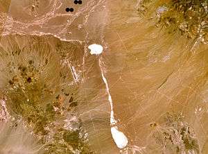 Cactus Flat is the location of the Tonopah Test Range Airport (left of center). | |
| Floor elevation | 1630 |
| Geography | |
| Country | United States |
| State | Nevada |
| Borders on | Cactus Range and Kawich Range[1]:148 |
| Coordinates | 37°41′N 116°40′W [2] |
The Kawich Range lies to the northeast and the Cactus Range to the southwest. Jack Rabbit Knob is 11.5 km (7.1 mi) east of Antelope Lake playa in Cactus Flat.[6]
Cactus Flat has three cactus types (Beavertail cactus, Calico cactus and Barrel cactus).[1]:66
References
- Carlson, Helen S. Nevada Place Names: A Geographical Dictionary. p. 225. Retrieved 2010-10-30.
- "Cactus Flat". Geographic Names Information System. United States Geological Survey.
- "Boundary Descriptions and Names of Regions, Subregions, Accounting Units and Cataloging Units". USGS.gov. Retrieved 2010-05-16.
Central Nevada Desert Basin
- "Final Environmental Assessment for Sanitary Landfill Expansion of the Tonopah Test Range, Nye County, Nevada" (PDF). Archived from the original (PDF) on 2010-12-29. Retrieved 2010-12-07.
- "Nevada Wild Horse Range-Clark, Lincoln, and Nye Counties, Nevada" (PDF). Archived from the original (PDF) on 2011-06-15. Retrieved 2010-12-07.
- Cactus Flat, Nevada 1:100,000 scale topographic map, 37116-EM-TM-100, USGS, 1988
External links
- "Cactus-Sarcobatus Flats Watershed -- 16060013". Retrieved 2010-12-07.
This article is issued from Wikipedia. The text is licensed under Creative Commons - Attribution - Sharealike. Additional terms may apply for the media files.