Buayan
Buayan is a coastal barangay located at the eastern edge of General Santos in the Philippines. It is bounded by Baluan in the west, Ligaya in the north, Baluntay and Alabel in the east and Sarangani Bay in the south.
Buayan Barrio Buayan Heneral Santos Boeyan | |
|---|---|
| Barangay of Buayan City of General Santos | |
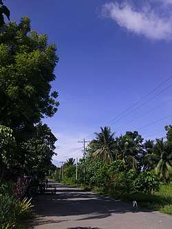
 At the "Jainal Abedin" street of Purok 1, Brgy. Buayan | |
| Nickname(s): BuaYan, Bua Ya | |
| Country | |
| Islands | Mindanao |
| Region | Soccsksargen (Region XII) |
| Province | South Cotabato (geographically only) |
| City | General Santos City |
| Government | |
| • Punong Barangay | Rogelio "Dodong" Solis Sr. |
| • Punong Kagawad | Lambac Nacua |
| Spoken languages | Cebuano, Hiligaynon, Ilocano |
| Coastal | Sarangani Bay |
Etymology
The barangay Buayan is a coastal barangay and bounded by the provincial capital municipality of Alabel, Buayan is a camp site of soldiers and also marines by the Philippine Air Force, destined by other regions in the Philippines are Ilocos Region, Cagayan Valley, Calabarzon, Mimaropa, Cebu, Caraga, Autonomous Region of Muslim Mindanao, Davao Region, and Zamboanga Peninsula, also the "Rajah Buayan Air Force" is situated in this barangay.
Education
Public Schools
- Datu Acad Dalid Elementary School
- Hermogenes Bayan Sr. Elementary School
- Buayan National High School - BNHS
- (Buayan Montesorri School)
Share settlements
Coastals
- Asinan Mangrove
- Minanga Mangrove Forest Park
gollark: HelloJas™.
gollark: Hmm, apparently it's transitive, not transistive.
gollark: What does what mean?
gollark: Calls aren't transistive but you can have multiple incoming calls.
gollark: Remember how you liked the esolangs discord server? We can now open bidirectional calls to it.
This article is issued from Wikipedia. The text is licensed under Creative Commons - Attribution - Sharealike. Additional terms may apply for the media files.