Brush Creek (Blue River tributary)
Brush Creek is a 10.5-mile-long (16.9 km)[2] stream that runs from Johnson County, Kansas, through Jackson County, Missouri. It is a tributary of the Blue River, and by the Blue and the Missouri rivers it is part of the Mississippi River watershed.
| Brush Creek | |
|---|---|
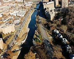 Brush Creek flowing through Kansas City, Missouri | |
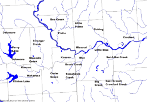 Kansas City metropolitan rivers with Brush Creek in the middle | |
| Location | |
| Country | United States |
| State | Kansas, Missouri |
| City | Kansas City |
| Physical characteristics | |
| Source | |
| • location | East Johnson County, Kansas, United States |
| • coordinates | 38°59′04″N 094°39′34″W[1] |
| • elevation | 741 ft (226 m) |
| Mouth | Blue River |
• location | Kansas City, Missouri, United States |
• coordinates | 39°02′20″N 094°31′14″W[1] |
• elevation | 222 ft (68 m)[1] |
| Length | 10.5 mi (16.9 km), East[2] |
| Basin features | |
| River system | Blue River |
Brush Creek begins near West 80th Street and Lamar Avenue in Overland Park, Kansas, and drains to the Blue River at Blue Banks Avenue and Hardesty Avenue in Kansas City.[2]
History
Brush Creek was named for the brush once lining its course.[3]
The Battle of Westport, the biggest battle in the American Civil War west of the Mississippi River, was fought on either side of it.
The Country Club Plaza is built on the banks of the creek. The expansive lawn of Nelson-Atkins Museum of Art runs from the steps of the museum down to the creek.
Attempts to control flooding on the creek by paving it with concrete produced by companies owned by Boss Thomas Pendergast were a scandal in the 1930s.[4]
Heavy rainfall in September 1977 resulted in Brush Creek flooding the Plaza with 5 to 6 feet (1.5 to 1.8 m) of water. The next stream westward, Turkey Creek on the Kansas side, also flooded at the same time. Twenty-five people died in the flood, and damage exceed $66 million.[5]
Today
Kansas City, Missouri, has a combined storm water and sanitary sewer system. During heavy rains, sewage from the sanitary sewer can overflow into the storm sewer and appear in local waterways. Several waterways, including Brush Creek, are posted with signs discouraging contact with the water after rain. Because of this, one local nickname for this stream is "Flush Creek". [6][7] As part of a settlement with the EPA, Kansas City has started a 25-year, $2.5 billion project to improve the city's sanitary and storm sewers, which should eliminate this problem.[8]
See also
References
- "Brush Creek". Geographic Names Information System. United States Geological Survey. 1978-10-13. Retrieved 2013-08-17.
- U.S. Geological Survey. National Hydrography Dataset high-resolution flowline data. The National Map Archived 2012-04-05 at WebCite, accessed May 31, 2011
- "Jackson County Place Names, 1928–1945 (archived)". The State Historical Society of Missouri. Archived from the original on 24 June 2016. Retrieved 13 October 2016.CS1 maint: BOT: original-url status unknown (link)
- Cole, Suzanne P.; Engle, Tim; Winkler, Eric (April 23, 2012). "50 things every Kansas Citian should know". The Kansas City Star. Retrieved April 23, 2012.
- Rex C. Buchanan & James R. McCauley, Roadside Kansas: A Traveler's Guide to Its Geology and Landmarks, 1987, University Press of Kansas.
- http://www.tonyskansascity.com/2012/10/flush-creek-watershed-moment.html
- "Archived copy". Archived from the original on 2010-12-12. Retrieved 2013-04-08.CS1 maint: archived copy as title (link)
- http://www.justice.gov/opa/pr/2010/May/10-enrd-584.html