Bristol Road
Bristol Road in the City of Gloucester dates from the medieval period. It runs between Southgate Street in the north and Quedgeley in the south where it joins the Bath Road and the A38. It contains a number of listed buildings and other notable structures.

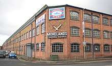
The former Moreland's match factory

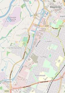
Bristol Road north

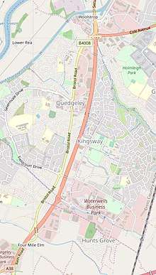
Bristol Road south

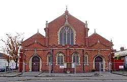
St Stephen's Church in 2018
History
Bristol Road was one of the significant roads into the City of Gloucester from the medieval period, joining it to the City of Bristol. Later, as Gloucester expanded, the northern-most part of Bristol Road became known as lower Southgate Street.[1]
Listed buildings and structures
Listed buildings and structures in Bristol Road, north to south, are:
- Norfolk Buildings, designed by Thomas Fulljames, 1836.[2]
- Gloucester & Sharpness Canal Milepost[3]
- The Little Thatch, 14th-century timber-framed house.[4]
- Forge Thatch Cottage, 17th-century timber-framed house.[5]
- Milestone, 19th-century, iron.[6]
- Packers Cottage, Quedgeley.[7]
- Laura Croft, 17th-century timber-framed house.[8]
- Milestone, 19th-century, iron.[9]
- Lodge to Hardwicke Court[10]
- Road Farmhouse, Hardwicke.[11]
- Milestone, Hardwicke, 19th-century, iron.[12]
Other buildings
- Gloucester Railway Carriage and Wagon Company (no longer exists)
- Moreland's Match Factory, makers of "England's Glory" matches.
- St Stephen's Church (formerly St Luke the Less) The church contains two First World War memorials. One to the men of the parish who died and a second to the men of Morelands match factory who died which was transferred from the factory.[13][14][15][16]
gollark: You're very good at this.
gollark: Fascinating.
gollark: Apparently, "rickroll".
gollark: What a real isotope which can physically exist.
gollark: Ah yes, "plutonium-22".
See also
References
- Medieval Gloucester: Topography. British History Online. Retrieved 4 April 2019.
- Historic England. "Norfolk Buildings (1245993)". National Heritage List for England. Retrieved 2 April 2019.
- Historic England. "Milepost (1245823)". National Heritage List for England. Retrieved 2 April 2019.
- Historic England. "Little Thatch (1090769)". National Heritage List for England. Retrieved 2 April 2019.
- Historic England. "Forge Thatch Cottage (1154581)". National Heritage List for England. Retrieved 2 April 2019.
- Historic England. "Milestone (1340606)". National Heritage List for England. Retrieved 2 April 2019.
- Historic England. "Packers Cottage (1303751)". National Heritage List for England. Retrieved 2 April 2019.
- Historic England. "Laura Croft (1154680)". National Heritage List for England. Retrieved 2 April 2019.
- Historic England. "Milestone (1304009)". National Heritage List for England. Retrieved 2 April 2019.
- Historic England. "Lodge to Hardwicke Court (1154072)". National Heritage List for England. Retrieved 2 April 2019.
- Historic England. "Road Farmhouse (1340588)". National Heritage List for England. Retrieved 2 April 2019.
- Historic England. "Milestone (1154037)". National Heritage List for England. Retrieved 2 April 2019.
- "Gloucester: Modern parish churches - British History Online". www.british-history.ac.uk.
- "Gloucester (St Stephen's Church WWI plaque) - War Memorials Online". www.warmemorialsonline.org.uk.
- Horton, Kim (28 March 2018). "This could become Gloucester's next new music venue". gloucestershirelive.
- "St Stephen's Church (parish of St Paul & St Stephen), Gloucester". churchdb. Retrieved 3 April 2019.
This article is issued from Wikipedia. The text is licensed under Creative Commons - Attribution - Sharealike. Additional terms may apply for the media files.