Breitentalskopf
The Breitentalskopf is a hill in the Harz Mountains of central Germany, that rises southeast of Sieber in the district of Göttingen in Lower Saxony. It is 579.1 m high and separates the River Sieber from the Breitental valley (with its stream, the Tiefenbeek), that gave the hill its name. Towards the southeast is the ridge of the Aschentalshalbe.
| Breitentalskopf | |
|---|---|
 Breitentalskopf | |
| Highest point | |
| Elevation | 579.1 m (1,900 ft) |
| Prominence | 39 m ↓ Gropenborn |
| Isolation | 1,365 km → Gropenbornskopf |
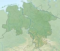
| Coordinates | 51°41′36″N 10°25′51″E |
| Geography | |
| Location | southeast of Sieber in Göttingen district in Lower Saxony, |
| Parent range | Harz Mountains |
Sources
- Topographic map 1:25000, No. 4328 Bad Lauterberg in Harz
gollark: That would work, I think?
gollark: I figure I need to do two passes through it, but my thing has an exciting variable width instruction encoding.
gollark: How do I assembler properly? I want "label" support in my "assembler", but I don't know how to have labels for stuff *after* the current place it's assembling work.
gollark: `MNZ FF 07 24` you?!
gollark: When the power button is pressed, automatic contrafelinous robots engage.
This article is issued from Wikipedia. The text is licensed under Creative Commons - Attribution - Sharealike. Additional terms may apply for the media files.