Breitenbach (Speyerbach)
Breitenbach is a river of Rhineland-Palatinate, Germany, a left tributary of the Speyerbach.
| Breitenbach | |
|---|---|
 | |
| Location | |
| Country | Germany |
| State | Rhineland-Palatinate |
| Reference no. | DE: 237834 |
| Physical characteristics | |
| Source | |
| • location | in the Dreibrunnental valley in the central Palatine Forest |
| • coordinates | 49°23′26″N 7°58′22″E |
| • elevation | 336 m above sea level (NN) |
| Mouth | |
• location | near Breitenstein into the Speyerbach |
• coordinates | 49°20′42″N 8°00′07″E |
• elevation | 194 m above sea level (NN) |
| Length | 6.74 km [1] |
| Basin size | 13.228 km² [1] |
| Basin features | |
| Progression | Speyerbach→ Rhine→ North Sea |
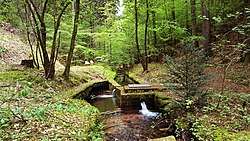
The Breitenbach rises in the central Palatine Forest in the valley of Dreibrunnental ("Three Springs Valley") and flows towards the south, where it forms the parish boundary between Elmstein and Esthal almost throughout. On the way it passes the Goldbrunnen spring. After about 10 kilometres it empties into the Speyerbach at the hamlet of Breitenstein (belongs to Esthal). The timber rafting station there is classed as a cultural monument; in the immediate vicinity of the confluence are the ruins of Breitenstein Castle.
Tributaries
- Finster-Breitenbach (right), 1.3 km
- Großer Schwabenbach (right), 1.7 km
gollark: https://hackaday.com/2020/02/16/have-led-bulbs-reached-their-final-and-cheapest-form/
gollark: I've read that they got the cost down by making the power supplies... perhaps excessively simple.
gollark: Incandescent lightbulbs... are still legal basically everywhere as far as I know?
gollark: Proof of their drone nature.
gollark: As if we needed more...
References
This article is issued from Wikipedia. The text is licensed under Creative Commons - Attribution - Sharealike. Additional terms may apply for the media files.