Bowman Coast
The Bowman Coast is the portion of the east coast of the Antarctic Peninsula between Cape Northrop and Cape Agassiz. It was discovered by Sir Hubert Wilkins in an aerial flight of December 20, 1928. It was named by Wilkins for Isaiah Bowman, then Director of the American Geographical Society.
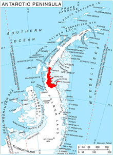
Location of Bowman Coast on the Antarctic Peninsula
Maps
- Antarctic Digital Database (ADD). Scale 1:250000 topographic map of Antarctica. Scientific Committee on Antarctic Research (SCAR). Since 1993, regularly upgraded and updated.
gollark: I think I'm using pikaur too.
gollark: Yes, that's totally not inconvenient.
gollark: You should probably install it from the AUR, if it is in that, which I think it is, using an AUR helper.
gollark: Yes, or another desktop manager or whatever it is.
gollark: I'm pretty sure it's in the AUR, all hail the AUR.
See also
Further reading
• Ute Christina Herzfeld, Atlas of Antarctica: Topographic Maps from Geostatistical Analysis of Satellite Radar Altimeter Data, PP 114, 168
• A. P. Crary, L. M. Gould, E. O. Hulburt, Hugh Odishow, Waldo E. Smith, editors, Antarctica in the International Geophysical Year, P 53
This article is issued from Wikipedia. The text is licensed under Creative Commons - Attribution - Sharealike. Additional terms may apply for the media files.