Bourré, Loir-et-Cher
Bourré is a former commune in the Loir-et-Cher département in central France. On 1 January 2016, it was merged into the new commune of Montrichard-Val-de-Cher.[2]
Bourré | |
|---|---|
Part of Montrichard-Val-de-Cher | |
 Coat of arms | |
Location of Bourré 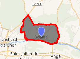
| |
 Bourré  Bourré | |
| Coordinates: 47°20′53″N 1°13′38″E | |
| Country | France |
| Region | Centre-Val de Loire |
| Department | Loir-et-Cher |
| Arrondissement | Blois |
| Canton | Montrichard |
| Commune | Montrichard-Val-de-Cher |
| Area 1 | 4.84 km2 (1.87 sq mi) |
| Population (2017)[1] | 654 |
| • Density | 140/km2 (350/sq mi) |
| Time zone | UTC+01:00 (CET) |
| • Summer (DST) | UTC+02:00 (CEST) |
| Postal code | 41400 |
| Elevation | 58–134 m (190–440 ft) (avg. 65 m or 213 ft) |
| 1 French Land Register data, which excludes lakes, ponds, glaciers > 1 km2 (0.386 sq mi or 247 acres) and river estuaries. | |
Population
| Year | Pop. | ±% |
|---|---|---|
| 1793 | 600 | — |
| 1800 | 583 | −2.8% |
| 1806 | 555 | −4.8% |
| 1821 | 607 | +9.4% |
| 1831 | 700 | +15.3% |
| 1836 | 731 | +4.4% |
| 1841 | 695 | −4.9% |
| 1846 | 772 | +11.1% |
| 1851 | 770 | −0.3% |
| 1856 | 1,043 | +35.5% |
| 1861 | 1,070 | +2.6% |
| 1866 | 1,105 | +3.3% |
| 1872 | 1,133 | +2.5% |
| 1876 | 1,197 | +5.6% |
| 1881 | 1,205 | +0.7% |
| 1886 | 1,163 | −3.5% |
| 1891 | 1,059 | −8.9% |
| 1896 | 1,071 | +1.1% |
| 1901 | 1,092 | +2.0% |
| 1906 | 1,150 | +5.3% |
| 1911 | 1,159 | +0.8% |
| 1921 | 1,002 | −13.5% |
| 1926 | 1,039 | +3.7% |
| 1931 | 1,007 | −3.1% |
| 1936 | 994 | −1.3% |
| 1946 | 975 | −1.9% |
| 1954 | 985 | +1.0% |
| 1962 | 1,025 | +4.1% |
| 1968 | 1,096 | +6.9% |
| 1975 | 1,099 | +0.3% |
| 1982 | 972 | −11.6% |
| 1990 | 832 | −14.4% |
| 1999 | 677 | −18.6% |
| 2006 | 735 | +8.6% |
| 2009 | 750 | +2.0% |
gollark: Expect deployment within 0.02 bee lifespans.
gollark: This is why ABRSearch™ is inevitable.
gollark: ddg! is it broken
gollark: Hmm, the DDG instant answers API isn't very hard.
gollark: I'm sure you'd like to think so.
This article is issued from Wikipedia. The text is licensed under Creative Commons - Attribution - Sharealike. Additional terms may apply for the media files.