Borchgrevink Nunatak
Borchgrevink Nunatak (66°3′S 62°30′W) is a nunatak 1.5 nautical miles (3 km) long which rises to 650 metres (2,130 ft), standing at the south side of the entrance to Richthofen Pass, on the east coast of Graham Land. It was discovered in 1902 by the Swedish Antarctic Expedition under Otto Nordenskiöld, who named it for C. E. Borchgrevink, leader of the British Antarctic Expedition, 1898–1900, to Victoria Land.[1]
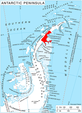
Location of Oscar II Coast on Antarctic Peninsula.
Further reading
- Faure, Gunter; Mensing, Teresa M. (2010). The Transantarctic Mountains: Rocks, Ice, Meteorites and Water. Dordrecht: Springer. p. 9. ISBN 978-90-481-9390-5.
- Mills, William James (2003). Exploring Polar Frontiers: A Historical Encyclopedia. Santa Barbara: ABC-CLIO. p. 161. ISBN 978-1-57607-422-0.
- Valle, R.; Lirio, J.; Lusky, J.; Morelli, J.; Nuñez, H. (December 1997). "Jurassic trees at Jason Peninsula, Antarctica". Antarctic Science. 9 (4): 443–444. doi:10.1017/S0954102097000576.
gollark: This is wrong, but differently, at least.
gollark: --remind 1m "queued at 17:54:whatever"
gollark: --magic reload_ext reminders
gollark: --remind 1m "queued at 17:51:whatever"
gollark: This is somehow worse.
External links
References
- "Borchgrevink Nunatak". Geographic Names Information System. United States Geological Survey. Retrieved 2011-08-02.
![]()
This article is issued from Wikipedia. The text is licensed under Creative Commons - Attribution - Sharealike. Additional terms may apply for the media files.