Bolivar Heights
Bolivar Heights is a plateau 668 feet (204 m) high located in Jefferson County, West Virginia, in the United States.[1] It overlooks the towns of Harpers Ferry and Bolivar, West Virginia. During the American Civil War, it featured more fighting than any other part of Harpers Ferry.
History
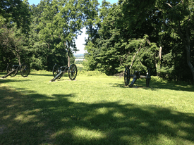
Bolivar Heights is a plateau that is 668 feet (204 meters) high, located near the towns of Bolivar, West Virginia and the town of Harpers Ferry. During the American Civil War, it was the site of the October 1861 Battle of Bolivar Heights, during which Confederate States Army colonel Turner Ashby failed to capture the heights from Union commander John White Geary. In 1862, the Bolivar Heights were used by Confederate general Stonewall Jackson to bombard Harpers Ferry, which was attacked during the Maryland Campaign. It was also attacked many other times, including Jubal Early's invasion of Maryland in 1864. There are cannon and a defensive trench preserved from the Civil War today, and it is one of the designated historical locations of the National Park Service, part of the Harpers Ferry National Historical Park.
References
National Park Service. "Place (U.S. National Park Service)." U.S. Department of the Interior, 8 June 2014. Web. 8 June 2014.