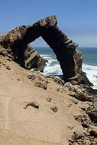
Bogenfels
Bogenfels is a location in the coastal Namib Desert of Namibia, noted for its natural rock formations (hence the name, which means "arch rock" in German).[1] The main formation is a 55-metre (180 ft) high rock arch close to the coast. It is not easily accessible, due to the terrain and its location within a restricted diamond-mining area Sperrgebiet, at 27° 28'S, about 95 kilometres (59 mi) south of Lüderitz and 32 kilometres (20 mi) south of Pomona but there are official guided tours.
.jpg)
Geology
With its highest point at 55 metres (180 ft) above sea level, the formation is a mix of hard dolomite and soft shale.
Town
A settlement developed in the area after diamonds were discovered. In 1950, it was evacuated and has remained a ghost town since. A narrow-gauge railway line once ran to Kolmanskop.
Philately
From 1931 to 1996, South West Africa and later Namibia issued postage stamps depicting the Bogenfels.
References
- Cassidy, Joseph. Place Names of Namibia: A Historical Dictionary. Macmillan Education Namibia Publishers (Pty) Ltd. p. 1. ISBN 978-99916-0-654-5.