Benson Municipal Airport (Arizona)
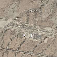
Benson Municipal Airport (FAA LID: E95) is a public use airport located 3.5 miles (3.0 nmi; 5.6 km) northwest of the central business district of Benson, a city in Cochise County, Arizona, United States and 35 miles (30 nmi; 56 km) east of Tucson International Airport (TUS).[1] The airport was opened in November 1999.
Benson Municipal Airport | |||||||||||
|---|---|---|---|---|---|---|---|---|---|---|---|
 | |||||||||||
| Summary | |||||||||||
| Airport type | Public | ||||||||||
| Owner/Operator | City of Benson | ||||||||||
| Serves | Benson, Arizona | ||||||||||
| Elevation AMSL | 3,831 ft / 1,168 m | ||||||||||
| Coordinates | 31°59′58″N 110°21′29″W | ||||||||||
| Website | southwesternaviation.com | ||||||||||
| Map | |||||||||||
 E95  E95 | |||||||||||
| Runways | |||||||||||
| |||||||||||
| Statistics (2017) | |||||||||||
| |||||||||||
Source: Federal Aviation Administration | |||||||||||
Although most US airports use the same three-letter location identifier for the FAA, IATA, and ICAO 'Benson Municipal Airport is only assigned E95 by the FAA.[2]
Facilities and aircraft
Benson Municipal Airport covers an area of 140 acres (57 ha) at an elevation of 3,831 ft (1,168 m) above mean sea level. It has one runway:
For the 12-month period ending April 15, 2017, the airport had 24,400 aircraft operations, an average of 67 per day: 92% general aviation, and 2% military. At that time there were 38 aircraft based at this airport: 84% single-engine, 5% ultralight, 3% multi-engine, 5% jet, and 3% helicopters.
Awards and recognition
In 2012 the 1955 Dodge Coronet Airport Courtesy Car at Benson Municipal provided by FBO SouthWestern Aviation, LLC was named "Airport Car of the Month" for June by EAA Sport Aviation Magazine.[4]
References
- FAA Airport Master Record for E95 (Form 5010 PDF)
- "E95 - Benson [Muni], AZ, US - Airport - Great Circle Mapper". www.gcmap.com. Retrieved 2018-05-15.
- "AirNav: E95 - Benson Municipal Airport". www.airnav.com. Retrieved 2018-05-15.
- "Airport car of the month". Sport Aviation: 8. June 2012.
External links
- Benson Municipal Airport at Arizona DOT Airport Directory
- SouthWestern Aviation, LLC
- Resources for this airport:
- FAA airport information for E95
- AirNav airport information for E95
- FlightAware airport information and live flight tracker
- SkyVector aeronautical chart for E95