Baykal Point
Baykal Point (Bulgarian: нос Байкал, ‘Nos Baykal’ \'nos bay-'kal\) is the mostly ice-covered rocky point projecting 800 m south-southwestwards into Lanusse Bay on the west coast of Brabant Island in the Palmer Archipelago, Antarctica.
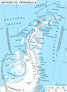
Location of Brabant Island in the Antarctic Peninsula region.
The point is named after the settlements of Baykal in Northern and Baykalsko in Western Bulgaria.
Location
Baykal Point is located at 64°12′50″S 62°29′06″W, which is 2.63 km east-southeast of Driencourt Point, 6.55 km northwest of Mount Parry and 5.4 km north-northeast of Minot Point. British mapping in 1980 and 2008.
Maps
- Antarctic Digital Database (ADD). Scale 1:250000 topographic map of Antarctica. Scientific Committee on Antarctic Research (SCAR). Since 1993, regularly upgraded and updated.
- British Antarctic Territory. Scale 1:200000 topographic map. DOS 610 Series, Sheet W 64 62. Directorate of Overseas Surveys, Tolworth, UK, 1980.
- Brabant Island to Argentine Islands. Scale 1:250000 topographic map. British Antarctic Survey, 2008.
gollark: You *also* seem to lean "control" under economics for whatever reason.
gollark: Added additionally to YOUR apiological profile.
gollark: βεες.
gollark: I mean "apiaristical" in the general sense of "I am randomly responding with a vaguely esolangs-y word".
gollark: Apiaristical!
References
- Bulgarian Antarctic Gazetteer. Antarctic Place-names Commission. (details in Bulgarian, basic data in English)
- Baykal Point. SCAR Composite Antarctic Gazetteer.
External links
- Baykal Point. Copernix satellite image

Brabant Island seen from northeast, with Anvers Island (on the right) and Antarctic Peninsula in the background.
This article includes information from the Antarctic Place-names Commission of Bulgaria which is used with permission.
This article is issued from Wikipedia. The text is licensed under Creative Commons - Attribution - Sharealike. Additional terms may apply for the media files.