Bashkaro Pass
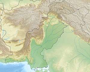
Bashkaro Pass or Bashkaro Top is a pass (class T - Hypsographic) in Pakistan, with the region font code of Asia/Pacific.[1]. It is located at an elevation of 4,924 meters above sea level. Its coordinates are 35°52'55" N and 72°32'27" E in DMS (Degrees Minutes Seconds) or 35.8819 and 72.5408 (in decimal degrees). Its UTM position is BV77 and its Joint Operation Graphics reference is NI43-01.
| Bashkaro Pass | |
|---|---|
| Kukush Pass | |
 Bashkaro Pass | |
| Elevation | 4,924 m (16,155 ft) |
| Location | Khyber Pakhtunkhwa, Pakistan |
| Coordinates | 35°52′55″N 72°32′27″E |
 | |
.jpg)
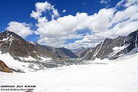
Bashkāro Pass is also known as Kukush Pass and Bashkarn An which connects Swat Valley with Ghizer Valley, GB[2]. A Pass is a break in a mountain range or other high obstruction, used for transportation from one side to the other. Its starting point is Mahodand Lake and the ending point is Langar, Ghizer[3]
The pass is a demanding and rarely crossed pass and link the upper Ghizar Valley with the Ushu Gol[4] in Kalam Kohistan to the south. This is approximately a 60km trek through Hinduksh range featuring mighty lakes rivers and glaciers.
See also
References
- Editor, T. N. S. (2017-12-17). "Hidden lakes of Swat". TNS - The News on Sunday. Retrieved 2019-07-19.CS1 maint: extra text: authors list (link)
- "Photos & thanks: Faizan Ahmad Bashkaro An (Pass), also known as Kukush Pass…". Swat Valley. 2019-07-11. Retrieved 2019-07-19.
- "Bashkaro An (Bashkaroan) Map, Weather and Photos - Pakistan: pass - Lat:35.8819 and Long:72.5408". www.getamap.net. Retrieved 2019-07-19.
- "KURU AN, ATAR PASS, DARMODAR HAGHOST, KALAM KOHISTAN , Dadarelli An, Bashkaro An". Trekking in Pakistan. 2017-02-09. Retrieved 2019-07-20.