Bankouale
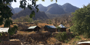
Bankouale (Arabic: بنكوالي) is a town in Tadjoura region of Djibouti. One of the distinctive features of Bankouale countryside is the widespread growing of vegetables. In the meantime there are also first approaches to establish gentle tourism.
Bankouale بنكوالي | |
|---|---|
Town | |
 | |
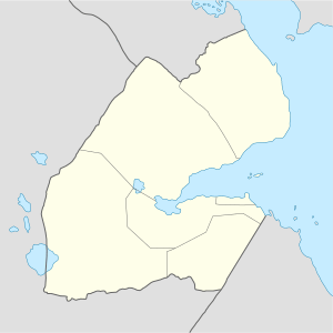 Bankouale بنكوالي Location in Djibouti | |
| Coordinates: 11°49′N 42°40′E | |
| Country | |
| Region | Tadjoura |
| Elevation | 640 m (2,100 ft) |
Climate
Bankouale has a hot semi-arid climate (BSh) in Köppen-Geiger system.
| Climate data for Bankouale | |||||||||||||
|---|---|---|---|---|---|---|---|---|---|---|---|---|---|
| Month | Jan | Feb | Mar | Apr | May | Jun | Jul | Aug | Sep | Oct | Nov | Dec | Year |
| Average high °C (°F) | 25.0 (77.0) |
25.2 (77.4) |
27.2 (81.0) |
29.4 (84.9) |
32.9 (91.2) |
36.5 (97.7) |
36.9 (98.4) |
35.9 (96.6) |
34.0 (93.2) |
30.1 (86.2) |
27.2 (81.0) |
25.5 (77.9) |
30.5 (86.9) |
| Average low °C (°F) | 16.0 (60.8) |
17.0 (62.6) |
18.3 (64.9) |
20.5 (68.9) |
23.2 (73.8) |
26.5 (79.7) |
25.6 (78.1) |
25.0 (77.0) |
25.0 (77.0) |
20.6 (69.1) |
18.1 (64.6) |
16.7 (62.1) |
21.0 (69.9) |
| Average precipitation mm (inches) | 30 (1.2) |
27 (1.1) |
18 (0.7) |
25 (1.0) |
10 (0.4) |
4 (0.2) |
16 (0.6) |
30 (1.2) |
29 (1.1) |
11 (0.4) |
38 (1.5) |
23 (0.9) |
261 (10.3) |
| Source: Climate-Data.org, altitude: 640m[1] | |||||||||||||
gollark: WELL YOUR REQUEST IS ENTIRELY UNREASONABLE.
gollark: Yes, I have seen it.
gollark: Soooo... why is <@236628809158230018> (meant to be) making a new shop with a confusing acronym when he already has Simplify?
gollark: It's hard to make one which:* does not crash immediately* connects to wallet okay* can be mined on* does not have messed up block value
gollark: Not really.
References
- "Climate: Bankouale - Climate graph, Temperature graph, Climate table". Climate-Data.org. Retrieved 6 September 2017.
External links
This article is issued from Wikipedia. The text is licensed under Creative Commons - Attribution - Sharealike. Additional terms may apply for the media files.