Bangladesh–Myanmar border
The Bangladesh–Myanmar border is the international border between the countries of Bangladesh and Myanmar (formerly Burma).[1] The border stretches 270 kilometres (170 miles), 210 km (130 mi) of which is fenced. The government of Myanmar announced in 2017 it was planning to fence off the rest of the border.[2][3]
| Bangladesh–Myanmar border | |
|---|---|
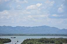
 Bangladesh & Myanmar border near BGB jetty ghat, Teknaf | |
| Characteristics | |
| Entities | |
| Length | 270 kilometres (170 mi) |
Refugees
Rohingya refugees use the border to cross over from Myanmar into Bangladesh.[4] Bangladesh and Myanmar have agreed to close their borders during sudden influxes of Rohingya refugees.[5] On Myanmar's side of the border in Maungdaw District, 80 percent of the population is Rohingya.[6]
gollark: Anyway. A replay attack could happen if your system encrypts "open the door" as, say, "a" constantly and "close the door" as "b" constantly. While the message is technically secure in that they can't arbitrarily encrypt a value, if someone wants to open the door they can just send "a".
gollark: Yep!
gollark: Still no.
gollark: You mean the protocol argument passed to rednet.send? No.
gollark: What?
See also
References
- James, Helen (2006). Security and Sustainable Development in Myanmar. Routledge. p. 120. ISBN 9781134253937. Retrieved 11 September 2017.
- "Myanmar to fence remaining border with Bangladesh". dhakatribune.com. Dhaka Tribune. Retrieved 11 September 2017.
- "Border fence upgrade for troubled Rakhine". Burma News International. Retrieved 11 September 2017.
- "Around 27,400 Rohingya flee into Bangladesh from Myanmar: UN sources". Channel NewsAsia. Retrieved 11 September 2017.
- "Bangladesh, Myanmar agree to consider sealing border if new crisis erupts". Frontier Myanmar. Retrieved 11 September 2017.
- Galache, Carlos Sardiña. "Rohingya Villagers Recount a Brutal Crackdown in Myanmar". Time. Retrieved 11 September 2017.
This article is issued from Wikipedia. The text is licensed under Creative Commons - Attribution - Sharealike. Additional terms may apply for the media files.