Aviré
Aviré is a former commune in the Maine-et-Loire department in western France. On 15 December 2016, it was merged into the new commune Segré-en-Anjou Bleu.[2]
Aviré | |
|---|---|
Part of Segré-en-Anjou Bleu | |
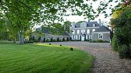 The Château de La Montchevalleraie | |
Location of Aviré 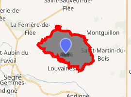
| |
 Aviré  Aviré | |
| Coordinates: 47°42′25″N 0°47′42″W | |
| Country | France |
| Region | Pays de la Loire |
| Department | Maine-et-Loire |
| Arrondissement | Segré |
| Canton | Segré |
| Commune | Segré-en-Anjou Bleu |
| Area 1 | 14.36 km2 (5.54 sq mi) |
| Population (2017)[1] | 497 |
| • Density | 35/km2 (90/sq mi) |
| Time zone | UTC+01:00 (CET) |
| • Summer (DST) | UTC+02:00 (CEST) |
| Postal code | 49500 |
| Elevation | 28–87 m (92–285 ft) (avg. 72 m or 236 ft) |
| 1 French Land Register data, which excludes lakes, ponds, glaciers > 1 km2 (0.386 sq mi or 247 acres) and river estuaries. | |
Population
| Year | Pop. | ±% |
|---|---|---|
| 1793 | 771 | — |
| 1800 | 554 | −28.1% |
| 1806 | 749 | +35.2% |
| 1821 | 839 | +12.0% |
| 1831 | 1,007 | +20.0% |
| 1836 | 1,017 | +1.0% |
| 1841 | 963 | −5.3% |
| 1846 | 772 | −19.8% |
| 1851 | 804 | +4.1% |
| 1856 | 755 | −6.1% |
| 1861 | 740 | −2.0% |
| 1866 | 756 | +2.2% |
| 1872 | 684 | −9.5% |
| 1876 | 666 | −2.6% |
| 1881 | 712 | +6.9% |
| 1886 | 711 | −0.1% |
| 1891 | 693 | −2.5% |
| 1896 | 672 | −3.0% |
| 1901 | 603 | −10.3% |
| 1906 | 586 | −2.8% |
| 1911 | 653 | +11.4% |
| 1921 | 558 | −14.5% |
| 1926 | 508 | −9.0% |
| 1931 | 491 | −3.3% |
| 1936 | 505 | +2.9% |
| 1946 | 501 | −0.8% |
| 1954 | 462 | −7.8% |
| 1962 | 449 | −2.8% |
| 1968 | 407 | −9.4% |
| 1975 | 370 | −9.1% |
| 1982 | 405 | +9.5% |
| 1990 | 433 | +6.9% |
| 1999 | 424 | −2.1% |
| 2006 | 426 | +0.5% |
| 2009 | 445 | +4.5% |
| 2014 | 490 | +10.1% |
gollark: Didn't you say something about blood sugar? Maybe you should check that.
gollark: Touchscreens are to some extent the enemy of mankind. However, due to financial/phone-market constraints I have not been able to attain a phone with a hardware keyboard.
gollark: I would discriminate against all people who didn't discriminate against themselves.
gollark: `internal/support` is actually *not* magically specialcased in; rather, I have a channel on one of the secret ABR operations servers which is linked to that.
gollark: ++tel unlink internal support
References
- Téléchargement du fichier d'ensemble des populations légales en 2017, INSEE
- Arrêté préfectoral 28 September 2016 (in French)
| Wikimedia Commons has media related to Aviré. |
| Authority control |
|
|---|
This article is issued from Wikipedia. The text is licensed under Creative Commons - Attribution - Sharealike. Additional terms may apply for the media files.