Attigundi
Attigundi is a village in the Chikkamagalur district of Karnataka. It is governed locally by gram panchayat.[2] It is located near the Muthodi wildlife sanctuary[3] and the popular tourist destinations of Honnammana Halla waterfalls, Jhari falls, Galikere,[4] Bababudangiri[5] and Kemmangundi.[6][7] The average temperature is 20 degrees Celsius.[8]

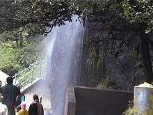
Manikyadhara falls on Baba Budangiri near Attigundi
Attigundi | |
|---|---|
village | |
.jpg) | |
 Attigundi Location in Karnataka, India  Attigundi Attigundi (India) | |
| Coordinates: 13.4333°N 75.7500°E | |
| Country | |
| State | Karnataka |
| District | Chikmagalur |
| Elevation | 1,448 m (4,751 ft) |
| Languages | |
| • Official | Kannada |
| Time zone | UTC+5:30 (IST) |
References
- https://elevationmap.net/attigundi-india
- "Archived copy". Archived from the original on 13 April 2017. Retrieved 12 April 2017.CS1 maint: archived copy as title (link)
- http://www.thehindu.com/todays-paper/tp-national/tp-karnataka/man-attacked-by-tiger/article5191735.ece
- https://www.deccanherald.com/fence-around-galikere-715974.html
- https://www.deccanchronicle.com/nation/current-affairs/041217/hindu-activists-hoist-saffron-flag-cops-resort-to-lathi-charge-at-bababudangiri.html
- https://books.google.com/books?id=tKsgAAAAIAAJ&q=%22Attigundi%22+-wikipedia&dq=%22Attigundi%22+-wikipedia&hl=en&sa=X&ved=0ahUKEwiVmKqwlfXiAhWKs48KHdqAD3oQ6AEIMzAC
- http://www.newindianexpress.com/states/karnataka/2017/jan/04/one-more-weapon-found-in-kemmanagundi-area-more-arrests-likely-1555952.html
- https://en.climate-data.org/location/757050/
This article is issued from Wikipedia. The text is licensed under Creative Commons - Attribution - Sharealike. Additional terms may apply for the media files.