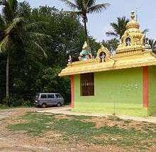
Athini
Location
Athini is located on the village road between Holenarasipura and Gorur dam. Aside from Gorur, nearby places include Karle, Chikkanahalli, Ganjalagodu and Arkalgud.
Demographics
Covering 266 hectares (660 acres) and comprising 210 households at the time of the 2011 census of India, Athini had a population of 989. There were 491 males and 498 females, with 91 people being aged six or younger.[1]
Post services
There is a post office in Athini and the PIN code is 573120.
Gallery
gollark: Apparently lots of malware now uses languages like Nim, Go and D to avoid detection by antivirii. The non-malware world should really try and keep up.
gollark: How advanced. Probably a version mismatch of some kind.
gollark: <@319753218592866315>
gollark: And imagine if Rust contained zygohistomorphic prepromorphisms.
gollark: Rust is by definition maximally fast, but Haskell includes eldritch optimizations which can be hypermaximally fast.
See also
References
- "Census of India 2011: Maharashtra Series 30, Part XII-B District Census Handbook Hassan Primary Census Abstract" (PDF). Directorate of Census Operations Maharashtra. p. 284. Retrieved 3 February 2018.
This article is issued from Wikipedia. The text is licensed under Creative Commons - Attribution - Sharealike. Additional terms may apply for the media files.


