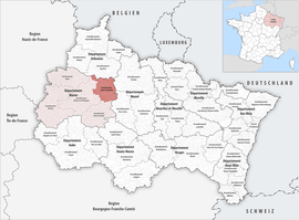
Arrondissement of Sainte-Menehould
The arrondissement of Sainte-Menehould is a former arrondissement of France in the Marne department in the Grand Est region. It was disbanded at the April 2017 reorganisation of the arrondissements of Marne.[1] It had 67 communes, and its population was 13,927 (2012).[2]
Sainte-Menehould | |
|---|---|
Former arrondissement | |
 Location within the region Grand Est | |
| Country | France |
| Region | Grand Est |
| Department | Marne |
| No. of communes | 67 |
| Disbanded | 2017 |
| Subprefecture | Sainte-Menehould |
| Area | |
| • Total | 1,021 km2 (394 sq mi) |
| Population (2012) | |
| • Total | 13,927 |
| • Density | 14/km2 (40/sq mi) |
Composition
The communes of the arrondissement of Sainte-Menehould, and their INSEE codes, were:[2]
History
The arrondissement of Sainte-Menehould was created in 1800, disbanded in 1926 and restored in 1940.[3] It was disbanded again in April 2017, and its communes joined the arrondissement of Châlons-en-Champagne.[1] As a result of the reorganisation of the cantons of France which came into effect in 2015, the borders of the cantons are no longer related to the borders of the arrondissements. The cantons of the arrondissement of Sainte-Menehould were, as of January 2015:[2]
- Givry-en-Argonne
- Sainte-Menehould
- Ville-sur-Tourbe
References
- Décret n° 2017-453 du 29 mars 2017 portant suppression de l'arrondissement de Sainte-Menehould (département de la Marne) (in French)
- "Populations légales 2012" (PDF). INSEE. December 2014. Retrieved 2019-10-07.
- Historique de la Marne