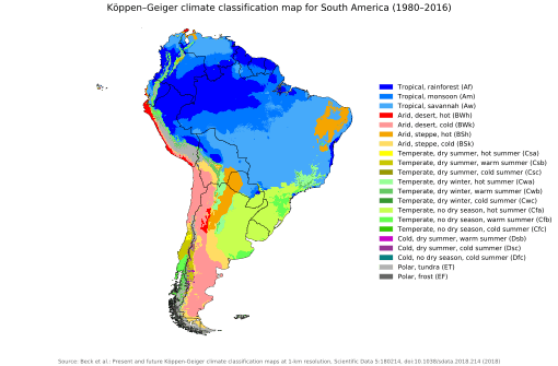
Arid Diagonal
The Arid Diagonal (Spanish: diagonal árida/arreica) is a contiguous zone of arid and semi-arid climate that traverses South America from coastal Peru in the Northwest to Argentine Patagonia in Southeast including large swathes of Bolivia and Chile.[1] The Arid Diagonal encompasses a number of deserts, for example: Sechura, Atacama, Monte and the Patagonian Desert.

The Arid Diagonal acts to isolate the temperate and subtropical forests of Chile and southern Argentina from other forests of South America.[2] Together with the Quaternary glaciations in the Southern Andes, the diagonal has controlled the distribution of vegetation throughout Chile and Argentina.[3]
Cause and origin
The northern portion of the Arid Diagonal is a result of the blocking of the trade winds by the barrier formed by the Central Andes and the South Pacific High[4] and to the south in the westerlies the rain shadow the Southern Andes casts over eastern Patagonia.[1] South of Mendoza (32°53' S), the driest parts of the diagonal move away from the Andes as the mountains lose height, causing some humidity to penetrate; thus, at more southern latitudes the driest parts of the diagonal lie on the Atlantic coast of Patagonia.[1]
The Arid Diagonal has existed since the Neogene.[3] The origin of the aridity of northern part of the diagonal is linked to two geologic events: a) the rise of Andes—an event that led to the permanent block of both the westward flow of moisture along the tropics, and the eastward flow of moisture in Patagonia[5] and b) the permanent intrusion of cold Antarctic waters (the Humboldt Current) along South America's west coast.[4] Together with the Quaternary glaciations in the Southern Andes the diagonal controls the distribution of the vegetation types over Chile and Argentina.[3]
References
- Bruniard, Enrique D. (1982). "La diagonal árida Argentina: un límite climático real". Revista Geográfica (in Spanish): 5–20.
- Villagrán, Carolina; Hinojosa, Luis Felipe (1997). "Historia de los bosques del sur de Sudamérica, II: Análisis fitogeográfico". Revista Chilena de Historia Natural (in Spanish). 70: 241–267.
- Villagrán, Carolina; Hinojosa, Luis Felipe (2005). "Esquema biogeográfico de Chile". In Llorente Bousquests, Jorge; Morrone, Juan J. (eds.). Regionalización Biogeográfica en Iberoámeríca y tópicos afines (in Spanish). Mexico: Ediciones de la Universidad Nacional Autónoma de México, Jiménez Editores.
- Armesto, Juan J.; Arrollo, Mary T.K.; Hinojosa, Luis F. (2007). "The Mediterranean Environment of Central Chile". In Veblen, Thomas T.; Young, Kenneth R.; Orme, Anthony R. (eds.). Physical Geography of South America. Oxford University Press. pp. 184–199.
- Folguera, Andrés; Encinas, Alfonso; Echaurren, Andrés; Gianni, Guido; Orts, Darío; Valencia, Víctor; Carrasco, Gabriel (2018). "Constraints on the Neogene growth of the central Patagonian Andes at thelatitude of the Chile triple junction (45–47°S) using U/Pb geochronology insynorogenic strata". Tectonophysics. 744: 134–154. doi:10.1016/j.tecto.2018.06.011. hdl:11336/88399.