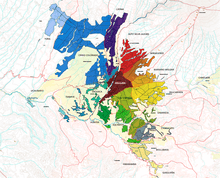
Arequipa metropolitan area
The Arequipa Metropolitan Area is the name used to refer to the metropolitan area whose principal city is Arequipa, according to Metropolitan Development Plan of Arequipa[1] According to population statistics of INEI It is the second most populous metropolitan area of Peru in year 2017.
Arequipa Metropolitan Area | |
|---|---|
| Country | |
| Region | Arequipa |
| Province | Arequipa Province |
| Population (2007 Census) | |
| • Total | 1,034,736 (2,017) |
| Time zone | UTC-5 (PET) |
Population

According to INEI the population of Arequipa metropolitan in the year 2007 was of 899.291 people[2] and according to Metropolitan Development Plan of Arequipa for year 2007 this had 822,479 people distributed in its metropolitan districts. According to the census 2007 and estimated population of INEI In the table is shown the population of Arequipa Metropolitan by districts:
| Metropolitan districts | Area km² |
Dwelling (Census 2007) |
Population minor to 1 year |
Density (pop./km²)* |
Elevation media msl* |
Distance to Arequipa (km)[3] |
Population Census 2007* |
Estimated Population 2015[4] |
|---|---|---|---|---|---|---|---|---|
| Alto Selva Alegre | 6.98 | 18,638 | 1,135 | 10,414.9 | 2,500 | 5 | 72,696 | 82,412 |
| Arequipa | 12.80 | 17,062 | 699 | 4,811.8 | 2,335 | 0 | 61,591 | 54,905 |
| Cayma ** | 246.31 | 20,267 | 1,227 | 303.6 | 2,403 | 2 | 74,776 | 91,802 |
| Cerro Colorado | 174.9 | 35,805 | 1,978 | 647.1 | 2,406 | 4 | 113,171 | 148,164 |
| Characato | 86.0 | 3,286 | 96 | 78.2 | 2.480 | 10 | 6,726 | 9,288 |
| Jacobo Hunter | 20.37 | 10,543 | 724 | 2,262.7 | 2,268 | 7 | 46,092 | 48,326 |
| José Bustamante | 10.83 | 18,806 | 1,070 | 7,055.4 | 2,310 | 2 | 76,410 | 76,711 |
| Mariano Melgar | 29.83 | 12,843 | 872 | 1,748.0 | 2,385 | 3 | 52,144 | 52,667 |
| Miraflores | 28.68 | 13,133 | 742 | 1,767.9 | 2,430 | 1 | 50,704 | 48,677 |
| Mollebaya | 36.6 | 588 | 25 | 38.5 | 2,483 | 7 | 1,410 | 1,868 |
| Paucarpata | 31.7 | 29,351 | 1,982 | 5061.4 | 2,405 | 3 | 160,446 | 124,755 |
| Quequeña | 34.93 | - | - | 34.9 | 2,536 | - | 1,219 | 1,376 |
| Sabandía | 537 | 1,178 | 56 | 6.9 | 2,220 | 8 | 3,699 | 4,136 |
| Sachaca | 36.63 | 4,806 | 273 | 478.8 | 2,390 | 4 | 17,537 | 19,581 |
| Socabaya | 18.64 | 16,069 | 853 | 3,201.2 | 2,300 | 3 | 59,671 | 78,135 |
| Tiabaya | 31.62 | 3,761 | 247 | 464.2 | 2,178 | 8 | 14,677 | 14,768 |
| Uchumayo | 22.14 | 3,280 | 175 | 482.0 | 1,950 | 16 | 10,672 | 12,436 |
| Yanahuara | 2.2 | 6,626 | 217 | 10,404.5 | 2,390 | 3 | 22,890 | 25,483 |
| Yura | 1,942.9 | 6,179 | 273 | 8.1 | 2,590 | 28 | 16,020 | 25,367 |
| Total | 3,311.1 | 218,938 | 12,644 | 260.5 | 2,335 | 0 | 822,479[1] | 920,857 |
| *Census 2007 - INEI | ||||||||
2017 Census
| Metropolitan districts | Surface km² |
Altitude msnm |
Distance to the Historical Center (km)[3] |
Población 2017[5] | ||||
|---|---|---|---|---|---|---|---|---|
| Arequipa | 12,8 | 2335 | 0 | 55 437 | ||||
| Alto Selva Alegre | 6,98 | 2500 | 5 | 85 870 | ||||
| Cayma | 246,31 | 2403 | 2 | 91 935 | ||||
| Cerro Colorado | 174,9 | 2406 | 4 | 197 954 | ||||
| Characato | 86,0 | 2480 | 10 | 12 949 | ||||
| Chiguata | 460,81 | 2946 | 30 | 2939 | ||||
| Jacobo Hunter | 20,37 | 2268 | 7 | 50 164 | ||||
| José Bustamante | 10,83 | 2310 | 2 | 81 829 | ||||
| Mariano Melgar | 29,83 | 2385 | 3 | 59 918 | ||||
| Miraflores | 28,68 | 2430 | 1 | 60 589 | ||||
| Mollebaya | 36,6 | 2483 | 7 | 4756 | ||||
| Paucarpata | 31,7 | 2405 | 3 | 131 346 | ||||
| Quequeña | 34,93 | 2536 | - | 4784 | ||||
| Sabandía | 537 | 2220 | 8 | 4368 | ||||
| Sachaca | 36,63 | 2390 | 4 | 24 225 | ||||
| Socabaya | 18,64 | 2300 | 3 | 75 351 | ||||
| Tiabaya | 31,62 | 2178 | 8 | 16 191 | ||||
| Uchumayo | 22,14 | 1950 | 16 | 14 054 | ||||
| Yanahuara | 2,2 | 2390 | 3 | 25 417 | ||||
| Yarabamba | 492,2 | 2474 | - | 1314 | ||||
| Yura | 1942,9 | 2590 | 28 | 33 346 | ||||
| Total | 4264,07 | - | - | 1 034 736 | ||||
| Datos del XII Censo de Población, VII de Vivienda y III de Comunidades Indígenas 2017[5] | ||||||||
Graphics of evolution of the population
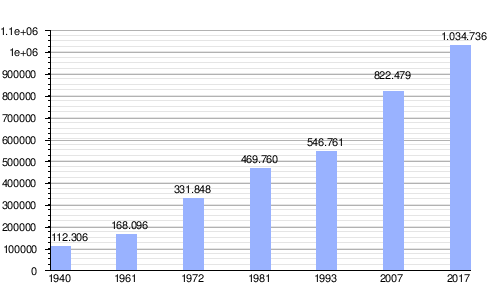
In the following Graphics the evolution of the population of Arequipa metropolitan area.
| evolution of the population of Arequipa metropolitan area |
|---|
 |
| Sources: Population 1940, 1961, 1972, 1981,[6] 1993,2007[1] Population 2015[4] |
See also
- Arequipa province
- List of metropolitan areas of Peru
- Peru
References
- "Plan de Desarrollo Metropolitano de Arequipa 2012-2022 (Pag. 34)".
- INEI, ed. (2011). "(spanish)INEI:Arequipa Compendio estadístico 2011 - Arequipa Metropolitana, Población censada y estimada, Según Distritos (page 77)". Retrieved October 25, 2012.
- Instituto Nacional de Estadística e Informática Distancia y tiempo que hay de la capital distrital a la capital provincial
- "Perú:Estimaciones y proyecciones de Población Por sexo según Departamento, Provincia y Distrito 2012-2015 - INEI".
- "Directorio Nacional de Centros Poblados - Censos Nacionales 2017". INEI. Retrieved 10 October 2018.
- Municipalidad de Arequipa. "Plan Director de Arequipa Metropolitana 2002-2015" (in Spanish).