Archimedes Geo3D
Archimedes Geo3D is a software package for dynamic geometry in three dimensions. It was released in Germany in March 2006 and won a German government award for outstanding educational software in 2007 .
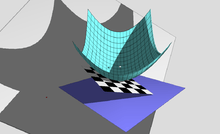
A locus surface constructed with Archimedes Geo3D
Advanced features
Archimedes Geo3D can trace the movement of points, lines, segments, and circles and generate locus lines and surfaces. Arbitrary objects can be intersected with lines, locus lines, and planes.
gollark: I tried:- looking at the "network" section in browser debug tools - nothing for the websocket appears- running it through mitmproxy - no request appears for the websocket thingy- capturing it with wireshark with TLS decryption on - inconclusive, I can't really figure out how to work that properly
gollark: Anyone know why all my websocket stuff goes "can't establish a connection to the server wss://whatever" in firefox? Specifically websocket stuff on my server, other things appear to work fine. It works in chromium or wscat, and the individual applications work fine in firefox if they're not behind my reverse proxy.
gollark: Another useful one is transmitting shopping lists from the future, so you can get things *before* you run out!
gollark: One of many practical everyday uses for time machines.
gollark: So just use a time machine to connect your internet connection to the internet connection at 4-6 am.
References
- "digita Förderpreis Archimedes Geo3D". Archived from the original on 14 November 2007. Retrieved 2007-11-08.
- "Dynamische Raumgeometrie". mathematik lehren. 144: 60. October 2007.
External links
This article is issued from Wikipedia. The text is licensed under Creative Commons - Attribution - Sharealike. Additional terms may apply for the media files.