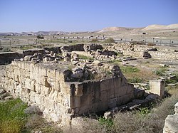
Archelais
Archelaïs was a town in the Roman province of Palaestina Prima, corresponding to modern Khirbet el-Beiyudat (also spelled Khirbet al-Bayudat). It was founded by Herod the Great's son Archelaus to house workers for his date plantation in the Jericho area.[1] It is represented on the Madaba mosaic map with a towered entrance flanked by two other towers.[2]

History
In Christian times, the town became a bishopric. The names of two of its bishops: Timotheus, who took part in two anti-Eutyches synods held in Constantinople in 448 and 449, and Antiochus, who was at the Council of Chalcedon in 451.[3][4]
No longer a residential bishopric, Archelaïs is today listed by the Catholic Church as a titular see.[5]
Inscriptions on the floor of a church discovered among the ruins of the town indicate that it was paved with Byzantine mosaics during the 560s.[6][7]
References
| Wikimedia Commons has media related to Archelais. |
- William Smith, Dictionary of Greek and Roman Geography, I, 193
- "Archelais - (Kh. al-Bayudat)" (Franciscan Cyberspot)
- Michel Lequien, Oriens christianus in quatuor Patriarchatus digestus, Paris 1740, Vol. III, coll. 673-676
- Pius Bonifacius Gams, Series episcoporum Ecclesiae Catholicae, Leipzig 1931, p. 453
- Annuario Pontificio 2013 (Libreria Editrice Vaticana 2013 ISBN 978-88-209-9070-1), p. 837
- H. Hizmi, "The Byzantine Church at Khirbet el-Beiyudat", in Christian Archaeology in the Holy Land. New Discoveries. Essays in Honour of Virgilio C. Corbo ofm (SBF Collectio Maior 36), Edd. G. C. Bottini - L. Di Segni - E. Alliata, Jerusalem 1990 – cited in "Archelais - (Kh. al-Bayudat)" (Franciscan Cyberspot)
- Hizmi, Hananya (2018). Archelaïs (mod. al-Bayudat, Kh. el-Beyudat): Ground plan of the church (fig. 2672.A). Corpus Inscriptionum Iudaeae/Palaestinae. Volume IV: Iudaea/Idumaea: 2649-3324. Walter de Gruyter. p. 43. ISBN 978-3-11-054421-3. Retrieved 1 June 2020.