Arc (Provence)
The Arc is an 83-kilometre (52 mi) long river in Southern France.[1] It arises at an elevation of 470 metres (1,540 ft), close to the village of Pourcieux. It then passes through Aix-en-Provence before flowing into the Étang de Berre, a lagoon connected with the Mediterranean Sea to the west of Marseille. Its drainage basin, with a surface area of 727 square kilometres (281 sq mi), is divided between two départments, Var and Bouches-du-Rhône. The Bayeux, the Cause and the Torse are its tributaries.
| Arc | |
|---|---|
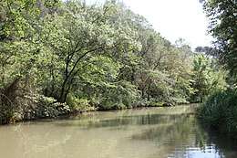 The Arc flowing near Aix-en-Provence | |
| Location | |
| Country | France |
| Physical characteristics | |
| Source | |
| • location | Pourcieux |
| • elevation | 470 m (1,540 ft) |
| Mouth | Étang de Berre |
• coordinates | 43°30′24″N 5°6′49″E |
| Length | 83 km (52 mi) |
| Basin size | 727 km2 (281 sq mi) |
| Basin features | |
| Progression | Étang de Berre→ Mediterranean Sea |
The Roquefavour Aqueduct passes over the river; Paul Cézanne's Mont Sainte-Victoire and the Viaduct of the Arc River Valley is the best known piece of art representing the Arc.
References
This article is issued from Wikipedia. The text is licensed under Creative Commons - Attribution - Sharealike. Additional terms may apply for the media files.