Araçariguama
Araçariguama is a city on the state of São Paulo in Brazil. It is part of the Metropolitan Region of Sorocaba.[1] The population of city is of 20,114 (2015 est.) in an area of 145.20 km².[2] The elevation is 695 m. Araçariguama was established in 1653.
Araçariguama | |
|---|---|
 Flag | |
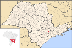
 Location in São Paulo state | |
 Araçariguama Location in Brazil | |
| Coordinates: 23°26′19″S 47°03′41″W | |
| Country | Brazil |
| Region | Southeast |
| State | São Paulo |
| Metrop. region | Sorocaba |
| Area | |
| • Total | 145.20 km2 (56.06 sq mi) |
| Elevation | 695 m (2,280 ft) |
| Population (2015) | |
| • Total | 20,114 |
| • Density | 140/km2 (360/sq mi) |
| Time zone | UTC-03:00 (BRT) |
| • Summer (DST) | UTC-02:00 (BRST) |
| Postal code | 18147 |
| Area code | +55 11 |
| Website | www |
Population history
| Year | Population |
|---|---|
| 2001 | 11,154 |
| 2004 | 13,324 |
| 2015 | 20,114 |
Demographics
According to the 2000 IBGE Census, the population was 11,154, of which 7,240 are urban and 3,914 are rural. The average life expectancy was 69.03 years. The literacy rate was 89.99%.
gollark: Doesn't Haskell not like infinite types?
gollark: This is a bad explanation because this takes away any ability to make meaningful statements about god. For example, let's say you say "god is good". Well, if they can just entirely ignore laws of logic, they can be good, bad and potatOS at the same time.
gollark: It's not a very good spec.
gollark: Oh, that's Rust, not macron.
gollark: `once(0).chain(once(1))` - do you not have `iter([0, 1])` or something?
References
- "Governo do Estado de São Paulo, Lei Complementar nº 1.241, de 8 de maio de 2014". Archived from the original on 2014-10-18. Retrieved 2015-09-29.CS1 maint: BOT: original-url status unknown (link)
- Instituto Brasileiro de Geografia e Estatística
External links
- (in Portuguese) http://www.aracariguama.sp.gov.br
- (in Portuguese) Araçariguama on citybrazil.com.br
This article is issued from Wikipedia. The text is licensed under Creative Commons - Attribution - Sharealike. Additional terms may apply for the media files.