Anna Paulowna
Anna Paulowna (Dutch pronunciation: [ˌɑnaː pəˈloːnaː] (![]()
Anna Paulowna | |
|---|---|
Former municipality | |
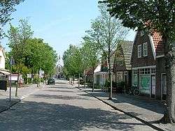 Church and the old center of the village Anna Paulowna. | |
 Flag  Coat of arms | |
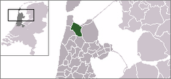 | |
| Coordinates: 52.87°N 4.87°E | |
| Country | Netherlands |
| Province | North Holland |
| Municipality | Hollands Kroon |
| Area (2006) | |
| • Total | 78.81 km2 (30.43 sq mi) |
| • Land | 74.43 km2 (28.74 sq mi) |
| • Water | 4.38 km2 (1.69 sq mi) |
| Population (1 January 2007) | |
| • Total | 13,999 |
| • Density | 188/km2 (490/sq mi) |
| Source: CBS, Statline. | |
| Time zone | UTC+1 (CET) |
| • Summer (DST) | UTC+2 (CEST) |
| Postcode | 1760-1766 |
| Area code(s) | 0223, 0224 |
| Website | www.annapaulowna.nl |
Population centres
The former municipality of Anna Paulowna consisted of the following cities, towns, villages and/or districts: Anna Paulowna, Breezand, Nieuwesluis, Van Ewijcksluis, and Wieringerwaard.
Transportation
The town is served by Anna Paulowna railway station.
Local government
The former municipal council of Anna Paulowna consisted of 15 seats. After the Dutch municipal elections of 2010 the seats were divided as follows:
See also
References
- Statistics are taken from the SDU Staatscourant
| Wikimedia Commons has media related to Anna Paulowna. |