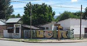
Aluminé (town)
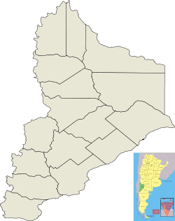
Aluminé is a second class municipality and the capital city of Aluminé Department located in Neuquén Province, Argentina.
Aluminé | |
|---|---|
City & Municipality | |
 Aluminé 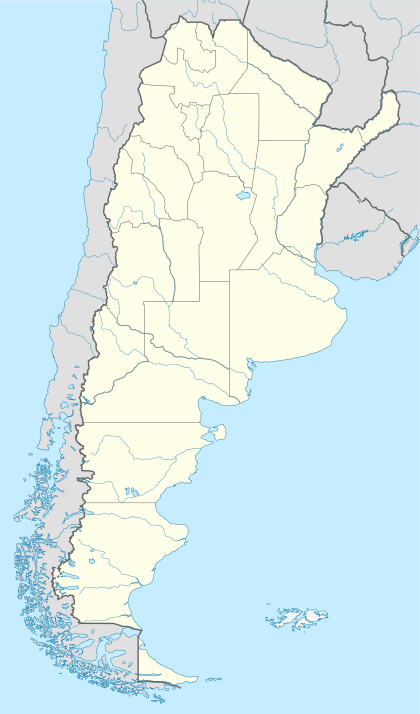 Aluminé | |
| Coordinates: 39°13′S 70°57′W | |
| Country | |
| Province | |
| Department | Aluminé Department |
| Founded | October 20, 1915 |
| Government | |
| • Mayor | Damián Romero |
| Elevation | 985 m (3,232 ft) |
| Population | |
| • Total | 3,720 |
| CPA Base | B 8345 |
| Area code(s) | +54 02942 |
| Climate | Csb |
| Website | www.alumine.gov.ar |
History
Aluminé was established in 1915, due to the departmental reorganization of the Neuquén Territory, today the Neuquén Province.
Geography
Located in the left shore of the Aluminé River, surrounded by mountains, is the entry to the "Distrito del pehuén" (Pehuen district) to the Mapuche community and the ten lakes: Quillén, Hui Hui, Rucachoroy, Pulmarí, Nonpehuén, Pilhue, Ñorquinco, Polcahue, Moquehue and Aluminé.
Climate
| Climate data for Aluminé, Neuquen (1993–2004) | |||||||||||||
|---|---|---|---|---|---|---|---|---|---|---|---|---|---|
| Month | Jan | Feb | Mar | Apr | May | Jun | Jul | Aug | Sep | Oct | Nov | Dec | Year |
| Average high °C (°F) | 24.9 (76.8) |
25.3 (77.5) |
22.4 (72.3) |
16.8 (62.2) |
12.7 (54.9) |
8.0 (46.4) |
8.2 (46.8) |
10.6 (51.1) |
13.5 (56.3) |
17.4 (63.3) |
20.0 (68.0) |
23.7 (74.7) |
17.0 (62.6) |
| Daily mean °C (°F) | 15.8 (60.4) |
15.4 (59.7) |
13.1 (55.6) |
8.9 (48.0) |
6.3 (43.3) |
3.4 (38.1) |
3.1 (37.6) |
4.6 (40.3) |
6.6 (43.9) |
9.7 (49.5) |
12.1 (53.8) |
14.8 (58.6) |
9.6 (49.3) |
| Average low °C (°F) | 6.7 (44.1) |
5.6 (42.1) |
3.9 (39.0) |
1.0 (33.8) |
−0.1 (31.8) |
−1.2 (29.8) |
−2.1 (28.2) |
−1.4 (29.5) |
−0.2 (31.6) |
1.9 (35.4) |
4.1 (39.4) |
6.2 (43.2) |
2.1 (35.8) |
| Record low °C (°F) | −5.0 (23.0) |
−7.5 (18.5) |
−13.0 (8.6) |
−12.5 (9.5) |
−12.0 (10.4) |
−15.0 (5.0) |
−18.0 (−0.4) |
−17.0 (1.4) |
−11.0 (12.2) |
−6.0 (21.2) |
−9.0 (15.8) |
−3.0 (26.6) |
−18.0 (−0.4) |
| Average precipitation mm (inches) | 18.0 (0.71) |
11.2 (0.44) |
27.3 (1.07) |
60.4 (2.38) |
80.7 (3.18) |
216.8 (8.54) |
140.3 (5.52) |
115.0 (4.53) |
66.2 (2.61) |
56.0 (2.20) |
38.0 (1.50) |
26.1 (1.03) |
856.0 (33.70) |
| Source: Instituto Nacional de Tecnología Agropecuaria[1] | |||||||||||||
gollark: Idea: abstract syntax graphs, instead of trees.
gollark: You... change the values of the nodes?
gollark: ↑
gollark: Or do you mean between games?
gollark: Save data as position/rotation/something?
References
- "Valles neuquinos: Regiones naturales" (in Spanish). Instituto Nacional de Tecnología Agropecuaria. Retrieved 10 October 2018.
This article is issued from Wikipedia. The text is licensed under Creative Commons - Attribution - Sharealike. Additional terms may apply for the media files.