Cernat, Covasna
Cernat (Hungarian: Csernáton; Hungarian pronunciation: [ˈtʃɛrnaːton]) is a commune in Covasna County, Transylvania, Romania composed of three villages:
- Albiș / Kézdialbis
- Cernat / Csernáton
- Icafalău / Ikafalva
Cernat Csernáton | |
|---|---|
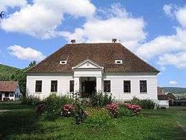
 The Damokos mansion-house, now Village Museum | |
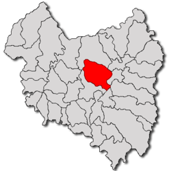
 Location in Covasna County | |
 Cernat Location in Romania | |
| Coordinates: 45°57′N 26°2′E | |
| Country | |
| County | Covasna |
| Government | |
| • Mayor | Dávid Bölöni (UDMR) |
| Area | 129 km2 (50 sq mi) |
| Population (2011)[1] | 3,978 |
| • Density | 31/km2 (80/sq mi) |
| Time zone | EET/EEST (UTC+2/+3) |
| Postal code | 527065 |
| Vehicle reg. | CV |
It formed part of Háromszék district of the Székely Land region in historical Transylvania. Cernat village was formed with the merger of two villages, Cernatu de Jos (Alsócsernáton) and Cernatu de Sus (Felsőcsernáton).
Demographics
The commune has an absolute Székely Hungarian majority. According to the 2011 Census it has a population of 3,956 of which 98.51% or 3,897 are Székely Hungarians.
gollark: that👏emoji👏use
gollark: Probably. But I don't think you can tell which is which unless you hardcode the positions or something.
gollark: Anyway, I haven't implemented *targeted* GPS spoofing yet, because it's not very useful and I don't control an entire dimension of GPS servers, but it might be interesting to experiment with.
gollark: It also relies on SPUDNET, which is closed-source right now because I can't be bothered to upload it somewhere.
gollark: The server is on my pastebin, but I never got round to writing a client for it.
References
- "Populaţia stabilă pe judeţe, municipii, oraşe şi localităti componenete la RPL_2011" (in Romanian). National Institute of Statistics. Retrieved 4 February 2014.
.jpg)
Reformed church in Albiș
This article is issued from Wikipedia. The text is licensed under Creative Commons - Attribution - Sharealike. Additional terms may apply for the media files.
