Allt-fawr
Allt-fawr is a mountain in Snowdonia, North Wales and forms part of the Moelwynion group.
| Allt-fawr | |
|---|---|
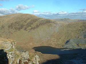 Allt Fawr from the Rhosydd quarry | |
| Highest point | |
| Elevation | 698 m (2,290 ft) |
| Prominence | 243 m (797 ft) |
| Parent peak | Moelwyn Mawr |
| Listing | Marilyn, Hewitt, Nuttall |
| Coordinates | 53°00′27″N 3°58′02″W |
| Naming | |
| English translation | big slope |
| Language of name | Welsh |
| Pronunciation | Welsh: [ˈaɬt ˈvaur] |
| Geography | |
| Parent range | Snowdonia |
| OS grid | SH681474 |
| Topo map | OS Landranger 115 |
| Listed summits of Allt-fawr | ||||
| Name | Grid ref | Height | Status | |
|---|---|---|---|---|
| Cnicht | 689 m (2,260 ft) | Hewitt, Nuttall | ||
| Moel Druman | 676 m (2,218 ft) | Hewitt, Nuttall | ||
| Ysgafell Wen | 672 m (2,205 ft) | Hewitt, Nuttall | ||
| Ysgafell Wen North Top | 669 m (2,195 ft) | Hewitt, Nuttall | ||
| Moel Meirch | 609 m (1,998 ft) | sub Hewitt | ||
It is on the internal border of Snowdonia National Park, and overlooks the town of Blaenau Ffestiniog, with its numerous slate quarries, as well as the Tanygrisiau reservoir and power station.[1] On the northern slope of Allt-fawr is the Oakeley Quarry, the world's largest underground slate mine. On the southern slope is the large Cwmorthin Quarry. These two mines are joined underneath the summit of Allt-fawr and the extensive chambering and adits are visible on the surface of the mountain where underground workings have collapsed.[2]
References
- Nuttall, John & Anne (1999). The Mountains of England & Wales - Volume 1: Wales (2nd edition ed.). Milnthorpe, Cumbria: Cicerone. ISBN 1-85284-304-7.
- J.G. Isherwood (1980). Candles to Caplamps: the Story of Gloddfa Ganol. Gloddfa Ganol.
This article is issued from Wikipedia. The text is licensed under Creative Commons - Attribution - Sharealike. Additional terms may apply for the media files.